Support our educational content for free when you purchase through links on our site. Learn more
Why Is Jacksonville the Largest City in the US? 🌆 (2026)
Ever stared at a map and thought, “How on earth is Jacksonville that big?” You’re not alone. Jacksonville, Florida, isn’t just a large city by population — it’s the largest city by land area in the contiguous United States, sprawling across more than 840 square miles! But what’s the story behind this massive footprint? Is it geography, politics, or just good old Southern ambition?
At Jax Facts™, we’ve lived, breathed, and driven every inch of this sprawling metropolis, and we’re here to unravel the mystery. From a game-changing 1968 government consolidation to the unique geography shaped by the St. Johns River and Atlantic coastline, this article covers it all. Plus, we’ll take you on a neighborhood tour, compare Jax to other major cities, and reveal how our size powers a booming economy and vibrant culture. Ready to discover why Jacksonville is truly a city like no other? Keep reading — the story gets even more fascinating.
Key Takeaways
- Jacksonville became the largest city by land area due to the 1968 consolidation of city and Duval County governments, expanding its boundaries dramatically.
- The city covers about 840 square miles, making it bigger than many entire states and vastly larger than other major cities like Miami or Los Angeles.
- Jacksonville’s geography includes the St. Johns River, 22 miles of Atlantic beaches, and extensive natural preserves, contributing to its vast footprint.
- Its size supports a diverse economy with major ports, military bases, and corporate headquarters, fueling growth and opportunity.
- The sprawling layout creates unique challenges and perks, from infrastructure demands to a rich patchwork of neighborhoods and lifestyles.
Curious about how Jacksonville’s size shapes its culture, economy, and daily life? Dive into our full guide to get the inside scoop!
Welcome to Jax Facts™! We’re your local squad of Duval devotees, here to dish the dirt (and the sand) on why our beloved “River City” is such an absolute unit. If you’ve ever looked at a map and wondered why Jacksonville looks like it’s trying to eat the rest of Florida, you’re in the right place.
We’ve spent years navigating the “Bold New City of the South,” from the hip streets of Five Points to the salty air of Jacksonville Beach, and we’ve got the inside scoop on how we became the heavyweight champion of land area. Grab a sweet tea from Publix, get comfortable, and let’s dive into the sprawling mystery of Jax! 🐊
Table of Contents
- ⚡️ Quick Tips and Facts
- 🏗️ The Big Bang of 1968: How Consolidation Created a Giant
- 🗺️ Land Area vs. Population: Settling the “Largest City” Debate
- 📏 7 Mind-Blowing Ways Jacksonville’s Size Compares to Other Cities
- 🌊 Geography of the Sprawl: From the St. Johns River to the Atlantic
- 🏙️ Neighborhood Deep Dive: Exploring the 840 Square Miles
- 💰 The Economic Engine: Why Being Big is Good for Business
- 🌉 Infrastructure and the “City of Bridges”
- 🏈 Culture and Lifestyle in the Bold New City
- 🏁 Conclusion
- 🔗 Recommended Links
- ❓ FAQ
- 📚 Reference Links
⚡️ Quick Tips and Facts
Before we get into the “how” and “why,” let’s look at the raw data. Jacksonville isn’t just a city; it’s an ecosystem.
| Feature | The “Jax” Fact |
|---|---|
| Total Land Area | ~840 Square Miles (Largest in the contiguous US) |
| County | Duval County (They are basically the same thing!) |
| Date of Consolidation | October 1, 1968 |
| Population Rank | 11th largest in the US (and growing!) |
| Nicknames | The River City, Jax, The Bold New City of the South |
| Major Waterway | St. Johns River (One of the few that flows North!) |
| Parks System | Largest urban park system in the United States |
Pro Tip: If you’re visiting, don’t expect to walk from one side of the city to the other. You’ll need a sturdy vehicle (we love our trucks here) and a SunPass for the tolls on the First Coast Expressway! 🚗
🏗️ The Big Bang of 1968: How Consolidation Created a Giant
To understand why Jacksonville is so massive, we have to travel back to the 1960s. Back then, Jacksonville was a typical mid-sized city struggling with the same issues many urban centers faced: a shrinking tax base, political corruption, and “white flight” to the suburbs.
In a move that was both radical and brilliant, the citizens voted to consolidate the city government with the Duval County government. On October 1, 1968, the city limits effectively expanded to match the county lines.
Why did we do it?
- ✅ Efficiency: It eliminated redundant government layers.
- ✅ Tax Base: It brought the wealthy suburbanites back into the city’s tax fold.
- ✅ Growth: It allowed for massive, coordinated infrastructure planning.
We like to think of it as the day Jacksonville swallowed its surroundings to become a “Super City.” While places like Miami or Tampa are surrounded by dozens of tiny municipalities, Jax is mostly one giant, unified block.
🗺️ Land Area vs. Population: Settling the “Largest City” Debate
You’ll often hear us bragging that we’re the “largest city in the US,” but we have to be honest with you—there’s a catch! 🎣
When people talk about the “largest” city, they usually mean one of two things:
- Population: In this category, New York City wears the crown. Jacksonville is currently the 11th most populous city.
- Land Area: This is where we shine. Jacksonville covers over 840 square miles.
Wait, what about Alaska? Technically, four cities in Alaska (like Sitka and Juneau) are larger in terms of total square mileage. However, Jacksonville holds the title for the largest city by land area in the contiguous United States (the lower 48). Take that, Houston! 🤠
📏 7 Mind-Blowing Ways Jacksonville’s Size Compares to Other Cities
To give you an idea of just how much room we have to roam, check out these comparisons:
- NYC Fit: You could fit the entire land area of Manhattan, Brooklyn, Queens, The Bronx, and Staten Island inside Jacksonville… twice. 🍎
- Miami Who?: Jacksonville is roughly 15 times larger in land area than the city of Miami.
- The Rhode Island Metric: We are about 70% the size of the entire state of Rhode Island.
- Commute Times: You can drive for an hour at 70 mph on I-295 and still be inside the Jacksonville city limits.
- Park Power: With over 80,000 acres of parks, our park system alone is larger than the entire city of Orlando.
- Beach Frontage: We boast 22 miles of beaches, which is more than some entire island nations!
- The “Pancake” Effect: Because we have so much land, we grow “out” instead of “up,” leading to a unique urban sprawl that feels more like a collection of interconnected towns.
🌊 Geography of the Sprawl: From the St. Johns River to the Atlantic
Our size isn’t just about dirt; it’s about water. The St. Johns River is the lifeblood of the city, snaking through downtown and creating stunning waterfront views in neighborhoods like Riverside and San Marco.
Key Geographic Features:
- The Intracoastal Waterway: A boater’s paradise that separates the mainland from the beach communities.
- The Atlantic Ocean: Our eastern border, home to Jacksonville Beach, Neptune Beach, and Atlantic Beach.
- Wetlands and Preserves: Huge chunks of our 840 square miles are protected lands, like the Timucuan Ecological and Historic Preserve.
❌ Common Misconception: People think Jacksonville is just one big concrete jungle. ✅ The Reality: A huge portion of our “city” is actually lush wetlands, pine forests, and pristine coastline.
🏙️ Neighborhood Deep Dive: Exploring the 840 Square Miles
Because we are so big, every “side” of town has its own personality. It’s like living in five different cities at once!
- The Northside: Home to the Jacksonville International Airport (JAX) and the Jacksonville Zoo and Gardens. It’s rugged, industrial, and full of nature.
- The Southside: The booming heart of retail and commerce. Think St. Johns Town Center (the ultimate shopping destination) and corporate headquarters.
- The Westside: A mix of rural charm and military history, featuring NAS Jacksonville.
- The Beaches: A laid-back, “salt life” vibe where the bike is the preferred mode of transportation.
- Urban Core: Historic districts like Springfield and Riverside Avondale, where you’ll find the best craft beer at Intuition Ale Works or Atypical.
💰 The Economic Engine: Why Being Big is Good for Business
Jacksonville’s massive footprint isn’t just for show; it’s a logistical powerhouse. We are known as the “Logistics Center of the Southeast.”
Why businesses love our size:
- JAXPORT: One of the largest commercial ports on the East Coast. Our size allows for massive terminals and easy rail access.
- Space to Grow: Unlike land-locked cities, we have plenty of room for massive distribution centers for companies like Amazon and Wayfair.
- Military Presence: We host multiple bases, including NS Mayport and NAS Jax, which pump billions into the local economy.
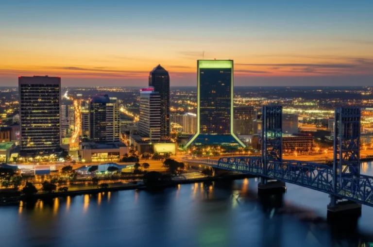
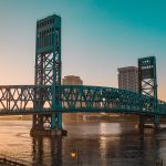
🌉 Infrastructure and the “City of Bridges”
You can’t talk about Jax’s size without talking about how we get around. We are often called the “City of Bridges” because the St. Johns River is so wide, we had to build some massive structures to cross it.
The Big Players:
- The Dames Point Bridge: One of the largest cable-stayed bridges in the US. It’s an architectural marvel!
- The Acosta and Main Street Bridges: The iconic blue and orange backdrops of our downtown skyline.
Jax Facts™ Tip: If you’re driving the “Buckman Bridge” (I-295) during rush hour, bring a podcast. It’s a long span, and the views are great, but the traffic is a local rite of passage! 🎧
🏈 Culture and Lifestyle in the Bold New City
Does a big city mean big fun? Absolutely. Our size allows us to host massive events that smaller cities simply couldn’t handle.
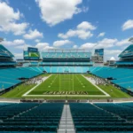
- The Jacksonville Jaguars: We are an NFL city, baby! Catch a game at EverBank Stadium and cool off in the famous end-zone pools.
- The Florida-Georgia Game: Also known as the “World’s Largest Outdoor Cocktail Party.” People take over the entire downtown area for this historic rivalry.
- The Gate River Run: The largest 15K in the United States, crossing our massive bridges.
We’re a blend of Southern hospitality and Florida sunshine. We say “y’all,” we love our Gators (and Seminoles), and we spend as much time on the water as possible.
🏁 Conclusion

So, why is Jacksonville the largest city in the US? It’s a mix of a bold political move in 1968, a unique geographic layout, and a desire to create a unified, powerhouse region. While we might not have the vertical density of New York, we have the “elbow room” that makes life here feel expansive and full of opportunity.
Whether you’re here for the 22 miles of beaches, the booming job market, or just to see a bridge that looks like it touches the clouds, Jacksonville’s size is its greatest strength. We aren’t just a city; we’re a destination that refuses to be contained!
🔗 Recommended Links
- Visit Jacksonville Official Site – The best place to plan your trip.
- City of Jacksonville (COJ.net) – Official government portal for consolidation history.
- JAX Chamber – Insights into the local economy and growth.
- The Florida Times-Union – Stay updated on local Duval news.
- Amazon – Jacksonville History Books – Dive deeper into the 1968 consolidation.
❓ FAQ

Q: Is Jacksonville bigger than Los Angeles? A: In terms of land area, yes! Jacksonville is about 840 square miles, while LA is roughly 469 square miles. However, LA has millions more people.
Q: Do I need a car to get around Jacksonville? A: 100% yes. Because of our size and sprawl, public transit (the JTA) exists, but a car is essential for exploring the different “sides” of town.
Q: Why is it called the “Bold New City of the South”? A: This was the slogan adopted during the consolidation in 1968 to signal a fresh start and a move away from the political corruption of the past.
Q: Is Jacksonville part of the “Florida Panhandle”? A: Nope! We are in Northeast Florida, often referred to as the “First Coast.”
📚 Reference Links
- U.S. Census Bureau – City Land Area Rankings
- The Florida Historical Quarterly – The Story of Consolidation
- National Park Service – Timucuan Preserve
- JAXPORT – Economic Impact Studies
⚡️ Quick Tips and Facts
Welcome to the heart of the matter! Before we unpack the sprawling story of why Jacksonville is the largest city in the US by land area, let’s hit you with some fast facts that will make your jaw drop and your curiosity spike.
| Feature | The Jax Facts™ Takeaway |
|---|---|
| Land Area | ~840 square miles — largest city by land area in the contiguous US (U.S. Census Bureau) |
| Population | Over 1 million residents as of 2024 estimates, ranking 11th in the US by population |
| Government | City-county consolidated government since 1968, merging Jacksonville and Duval County |
| Parks System | Largest urban park system in the US with over 80,000 acres, including the Timucuan Ecological Preserve |
| Waterfront | 1,100 miles of shoreline, including 22 miles of pristine Atlantic beaches (Visit Jacksonville) |
| Major Waterway | The St. Johns River, one of the few rivers in the world that flows north |
| Transportation Hubs | JAX Airport with nonstop flights to 30+ cities, major port (JAXPORT), and crossroads of I-10 and I-95 |
| Military Presence | Third largest military presence in the US, with bases like NAS Jacksonville and NS Mayport |
Why does this matter? Because Jacksonville isn’t just big on paper — it’s a city of diverse neighborhoods, economic power, and natural beauty all rolled into one massive package. If you’re curious about our local eats, check out our tasty guide on What Food Is Jacksonville, Florida Famous For? 🍤.
🏗️ The Big Bang of 1968: How Consolidation Created a Giant
The Political Masterstroke That Made Jacksonville a Behemoth
Jacksonville’s massive size didn’t happen by accident — it was a deliberate, strategic move known as city-county consolidation. Back in the 1960s, Jacksonville was struggling with urban decay, political corruption, and suburban flight. The solution? Merge the city government with Duval County’s government to create a single, unified entity.
- Date of Consolidation: October 1, 1968
- Result: City limits expanded to cover nearly all of Duval County, ballooning Jacksonville’s land area to over 840 square miles.
Why Consolidate?
- Efficiency: Eliminated overlapping services and government bureaucracy.
- Tax Base: Brought wealthy suburbs back into the city’s tax fold.
- Unified Planning: Allowed coordinated infrastructure and economic development.
What Did It Mean for Residents?
Imagine waking up one day and realizing your “city” is now the size of a small state. That’s what happened here. The consolidation made Jacksonville the largest city by land area in the contiguous US, a title it proudly holds today.
The Trade-Offs
- ✅ Streamlined governance and economic growth
- ✅ Unified identity for the region
- ❌ Challenges in providing services across such a vast area
- ❌ Some suburban areas still feel disconnected from downtown
For a deep dive into how this political move shaped our city’s identity, visit the City of Jacksonville’s official history page.
🗺️ Land Area vs. Population: Settling the “Largest City” Debate
What Does “Largest City” Really Mean?
When you hear “largest city,” you might picture New York City with its millions of people packed into skyscrapers. But Jacksonville’s claim to fame is a bit different — it’s the largest city by land area in the contiguous United States.
| Metric | Jacksonville, FL | New York City, NY | Los Angeles, CA |
|---|---|---|---|
| Land Area (sq mi) | ~840 | 302.6 | 469 |
| Population (2024) | ~1,009,833 | 8,000,000+ | 4,000,000+ |
| Population Density | ~1,200/sq mi | ~27,000/sq mi | ~8,500/sq mi |
Why Does This Matter?
- Jacksonville’s low population density means lots of open space, parks, and natural areas.
- The city’s urban sprawl is a direct result of its large land area.
- Population-wise, Jacksonville ranks 11th nationally, but its footprint dwarfs many bigger cities.
The Alaska Exception
While Jacksonville is the largest city by land area in the lower 48 states, some Alaskan cities like Sitka and Juneau are even bigger geographically. But since Alaska is a special case, Jacksonville holds the crown for the contiguous US.
What’s the Impact?
- Residents enjoy more space and less congestion than in denser cities.
- Public transit is limited, so a car is essential (JTA Transit).
- The city’s sprawling nature creates unique challenges for infrastructure and services.
📏 7 Mind-Blowing Ways Jacksonville’s Size Compares to Other Cities
Ready for some jaw-dropping comparisons? Here’s how Jacksonville stacks up against other well-known cities:
- Manhattan Times Five: You could fit all five boroughs of New York City inside Jacksonville’s land area — and still have room to spare!
- Miami Multiplied: Jacksonville is roughly 15 times larger than Miami in land area.
- Almost Rhode Island: Our city covers about 70% of the entire state of Rhode Island.
- Endless Commutes: Drive for an hour on I-295 at highway speeds, and you’re still inside Jacksonville city limits.
- Park Paradise: Our 80,000+ acres of parks are four times the size of Manhattan, including the massive Timucuan Preserve.
- Beach Bonanza: With 22 miles of beaches, Jacksonville offers more sandy shoreline than many entire island nations.
- Urban Sprawl: Unlike cities that grow up, Jacksonville grows out — creating a unique patchwork of neighborhoods and natural preserves.
Why Does Size Matter?
Our size means we have room to breathe — but it also means planning and infrastructure have to be top-notch to keep the city connected.
🌊 Geography of the Sprawl: From the St. Johns River to the Atlantic
The St. Johns River: Our Lifeline
One of Jacksonville’s most defining features is the St. Johns River, which flows northward through the city — a rare trait for a major river. It’s over 310 miles long and plays a huge role in our economy, recreation, and identity.
- The river divides the city into Northside and Southside.
- It’s home to JAXPORT, Florida’s largest seaport by volume.
- Waterfront neighborhoods like San Marco and Riverside offer stunning river views and historic charm.
The Atlantic Coastline
Jacksonville’s eastern boundary is the Atlantic Ocean, boasting:
- 22 miles of beaches stretching from Jacksonville Beach to Atlantic Beach and Neptune Beach.
- The Intracoastal Waterway, separating the mainland from the barrier islands.
- Access to boating, fishing, and surfing — a lifestyle many locals cherish.
Natural Preserves and Wetlands
A big chunk of Jacksonville’s area is protected land:
- The Timucuan Ecological and Historic Preserve covers 46,000 acres of wetlands, salt marshes, and historic sites.
- Other parks and preserves ensure that despite our size, nature remains a central part of life here.
Fun Fact:
Jacksonville has more shoreline than any other city in Florida (Visit Jacksonville).
🏙️ Neighborhood Deep Dive: Exploring the 840 Square Miles
Jacksonville isn’t just big — it’s a city of neighborhoods, each with its own vibe and character. Here’s a quick tour:
The Northside
- Home to Jacksonville International Airport (JAX).
- Features the Jacksonville Zoo and Gardens and NAS Jacksonville military base.
- Mix of industrial areas, residential neighborhoods, and natural spaces.
The Southside
- The commercial and retail hub, including the St. Johns Town Center (our premier shopping destination).
- Corporate headquarters for companies like CSX Corporation and Fanatics.
- Rapidly growing with new residential developments and business parks.
The Westside
- More rural and historic, with military installations like Naval Station Mayport nearby.
- Home to older neighborhoods and growing suburban communities.
The Beaches
- A laid-back coastal lifestyle with miles of sandy beaches.
- Popular spots include Jacksonville Beach, Neptune Beach, and Atlantic Beach.
- Known for surfing, fishing, and beach festivals.
The Urban Core
- Historic districts like Riverside and Avondale with artsy shops, craft breweries (Intuition Ale Works, Atypical Brewing), and local eateries.
- Downtown Jacksonville with its skyline, riverwalk, and cultural institutions like the Cummer Museum of Art and Gardens.
Insider Tip:
If you want to experience the city’s diversity, spend a day hopping between neighborhoods — from the hip vibes of Riverside to the salty air of the Beaches.
For more on Jacksonville’s culture and neighborhoods, check out our Jacksonville Culture category.
💰 The Economic Engine: Why Being Big is Good for Business
Jacksonville’s size isn’t just a curiosity — it’s a major economic advantage. Here’s why:
JAXPORT: The Logistics Powerhouse
- Florida’s largest seaport by volume, handling millions of tons of cargo annually.
- Supports industries from shipping to manufacturing.
- Connected to railroads and highways for efficient distribution.
Military Presence
- Home to Naval Air Station Jacksonville, Naval Station Mayport, and Marine Corps Support Facility Blount Island.
- Military employs over 30,000 active-duty personnel and nearly 20,000 civilians.
- This presence injects billions into the local economy annually.
Corporate Headquarters and Business Growth
- Jacksonville attracts companies like Fanatics, Firehouse Subs, and CSX Corporation due to:
- Business-friendly government policies.
- Reasonable cost of living.
- Access to transportation infrastructure.
Tourism Impact
- Tourism generates over $7 billion annually.
- Supports over 56,000 jobs.
- Events like the Florida-Georgia football game and Gate River Run bring huge crowds.
Why Size Matters for Business
- Plenty of land for warehouses, distribution centers, and industrial parks.
- Room for expansion without the sky-high costs of denser cities.
- Diverse economy spanning logistics, finance, healthcare, and tourism.
For more on Jacksonville’s economy, visit the JAX Chamber.
🌉 Infrastructure and the “City of Bridges”
Crossing the Mighty St. Johns
Jacksonville’s geography demands some serious infrastructure — especially bridges. The city is often called the “City of Bridges” because it has over 20 bridges spanning the St. Johns River and its tributaries.
| Bridge Name | Type | Key Facts |
|---|---|---|
| Dames Point Bridge | Cable-stayed | 2 miles long; one of the longest in the Western Hemisphere |
| Acosta Bridge | Bascule (drawbridge) | Connects downtown to Southbank |
| Main Street Bridge | Bascule (drawbridge) | Iconic blue bridge downtown |
| Fuller Warren Bridge | Girder | Carries I-95 over the river |
| Buckman Bridge | Girder | Carries I-295; popular commuter route |
Transportation Highlights
- Interstates 10 and 95 intersect here, making Jax a key transportation hub.
- JAX Airport offers nonstop flights to 30+ cities.
- Public Transit: Jacksonville Transportation Authority (JTA) operates buses and the Skyway monorail downtown.
- SunPass is essential for toll roads like the First Coast Expressway.
Challenges
- Maintaining and upgrading infrastructure across such a large area is costly.
- Traffic congestion on key bridges during rush hours is a local gripe.
- Public transit coverage is limited compared to denser cities.
Fun Fact
The Dames Point Bridge is not just functional — it’s a stunning piece of architecture often featured in postcards and local art.
🏈 Culture and Lifestyle in the Bold New City
Jacksonville’s size means it’s not just a city — it’s a region of cultures, lifestyles, and experiences.
Sports and Entertainment
- Home to the Jacksonville Jaguars (NFL) at EverBank Stadium, featuring unique amenities like swimming pools in the end zones.
- Hosts the annual Florida-Georgia football game, known as the “World’s Largest Outdoor Cocktail Party.”
- The Gate River Run, the largest 15K race in the US, draws runners nationwide.
Arts and Music
- Birthplace of Southern rock legends like Lynyrd Skynyrd and The Allman Brothers Band.
- Historic neighborhoods like LaVilla are known as the “Harlem of the South” for their rich African American cultural heritage.
- The Florida Theatre and Theatre Jacksonville offer live performances year-round.
- The Cummer Museum of Art and Gardens boasts a world-class collection and beautiful riverfront gardens.
Food Scene
- A melting pot of Southern, seafood, and international flavors.
- Don’t miss local favorites like Mayport shrimp, Cuban sandwiches, and Gator tail.
- For a deep dive into our culinary culture, check out What Food Is Jacksonville, Florida Famous For? 🍤.
Lifestyle Perks
- Over 270 days of sunshine annually.
- Access to beaches, rivers, parks, and golf courses.
- A youthful population with an average age of 36.
- Friendly Southern hospitality blended with Florida’s laid-back vibe.
What’s Next?
Jacksonville’s culture is evolving fast, with new breweries, art galleries, and festivals popping up across the city. It’s a place where tradition meets innovation — and the best is yet to come.
We’ve only just scratched the surface of what makes Jacksonville the largest and one of the most fascinating cities in the US. Curious about what locals think? Check out the perspective in the featured video for a visual tour and more insights from residents and historians alike!
🏁 Conclusion

So, why exactly is Jacksonville the largest city in the US? It all boils down to a bold political move in 1968 — the city-county consolidation — which expanded Jacksonville’s boundaries to encompass nearly all of Duval County. This strategic decision gave us a sprawling footprint of over 840 square miles, making us the largest city by land area in the contiguous United States. But it’s not just about size; our vast geography includes miles of pristine beaches, a mighty river, sprawling parks, and diverse neighborhoods that make Jacksonville a city of contrasts and opportunities.
Our large land area supports a robust economy fueled by logistics, military presence, tourism, and corporate headquarters, while our unique geography demands impressive infrastructure like the iconic Dames Point Bridge. The city’s culture is as expansive as its size — from NFL games and Southern rock roots to vibrant arts scenes and mouthwatering local cuisine.
If you were wondering whether Jacksonville’s size is a blessing or a challenge, the answer is: both. The sprawl offers room to grow and breathe but requires smart planning and strong community connections to keep everyone feeling part of the same city. And for visitors or new residents, understanding this vastness is key to appreciating what makes Jacksonville truly special.
In short, Jacksonville isn’t just big on the map — it’s big on heart, history, and hustle. Whether you’re here for the beaches, the business opportunities, or the culture, there’s plenty of room for you in the Bold New City of the South.
🔗 Recommended Links
If you want to explore Jacksonville further or dive into its rich history, culture, and geography, here are some great resources and products to check out:
-
Books on Jacksonville History and Culture:
- Jacksonville: The Consolidation Story by Wayne Wood
- Bold New City of the South: Jacksonville’s Transformation by Michael Gannon
- Florida’s First Coast: A Natural and Cultural History by Larry E. Rivers
👉 Shop on Amazon:
-
Local Craft Beer & Brewery Gear:
- Intuition Ale Works: Shop Intuition Ale Works on Amazon
- Atypical Brewing: Shop Atypical Brewing on Amazon
-
Outdoor & Beach Gear:
- Sun protection and beach essentials for Jacksonville’s 22 miles of beaches:
-
Transportation Essentials:
- SunPass for toll roads: SunPass Official Website
❓ FAQ

How does Jacksonville’s city layout impact its status as the largest city in the country?
Jacksonville’s city layout is unique because the city and Duval County governments consolidated in 1968, merging their boundaries. This means Jacksonville’s city limits cover nearly the entire county, resulting in a sprawling city that encompasses urban, suburban, rural, and natural areas. This consolidation is why Jacksonville’s land area is so vast, making it the largest city by land area in the contiguous US. The layout creates a patchwork of neighborhoods and preserves, which impacts infrastructure, public services, and transportation planning.
What historical events led to Jacksonville becoming the largest city by area in the US?
The pivotal event was the 1968 city-county consolidation, where Jacksonville merged with Duval County government. This political move was designed to combat urban decline, streamline government services, and unify the region economically and administratively. By expanding the city limits to match the county, Jacksonville’s land area ballooned from a typical mid-sized city to a sprawling metropolis covering over 840 square miles.
How does Jacksonville’s population size compare to other major cities in Florida?
Jacksonville is the most populous city in Florida, with over 1 million residents as of 2024 estimates. It surpasses Miami and Tampa in population within city limits. However, Miami’s metropolitan area is larger in population. Jacksonville’s lower population density reflects its vast land area, meaning it feels less crowded than cities like Miami or Orlando.
What factors contribute to Jacksonville’s large land area compared to other US cities?
The main factor is the city-county consolidation with Duval County in 1968, which expanded Jacksonville’s boundaries to cover almost the entire county. Additionally, Jacksonville’s geography includes large tracts of wetlands, parks, and undeveloped land, which contribute to its extensive area. Unlike cities that have many smaller municipalities around them, Jacksonville is mostly one unified city, which inflates its land area compared to fragmented urban regions.
Why is Jacksonville more populated than Miami?
Jacksonville’s population within city limits is larger than Miami’s because Miami is made up of many smaller municipalities and neighborhoods that are separate cities or towns. Miami’s population is spread across the Miami metropolitan area, which includes cities like Miami Beach, Coral Gables, and Hialeah. Jacksonville’s consolidation means all these areas are counted within its city population, giving it a higher official city population.
What is special about Jacksonville FL?
Jacksonville is special for several reasons: it is the largest city by land area in the contiguous US, boasts the largest urban park system in the nation, and has a rich cultural heritage including Southern rock music roots and historic neighborhoods. It also has a strategic location on the Atlantic coast with the St. Johns River flowing through it, a major military presence, and a diverse economy spanning logistics, tourism, and finance.
Why is Jacksonville the biggest city?
Jacksonville is the biggest city by land area because of the 1968 consolidation of the city and Duval County governments, which expanded the city limits to cover nearly 840 square miles. This political and administrative decision created a unified government for the entire county, making Jacksonville the largest city geographically in the contiguous United States.
📚 Reference Links
For further verification and detailed information, check out these reputable sources:
-
U.S. Census Bureau QuickFacts – Jacksonville, FL:
https://www.census.gov/quickfacts/jacksonvillecityflorida -
City of Jacksonville Official Website – About Jacksonville:
https://www.jacksonville.gov/departments/office-of-economic-development/about-jacksonville -
Visit Jacksonville – Research and Jax Facts:
https://www.visitjacksonville.com/about/research-information/jax-facts/ -
JAXPORT – Jacksonville Seaport Authority:
https://www.jaxport.com -
Jacksonville Transportation Authority (JTA):
https://www.jtafla.com -
Florida Theatre – Jacksonville’s Historic Venue:
https://floridatheatre.com -
Intuition Ale Works – Local Craft Brewery:
https://intuitionaleworks.com -
Atypical Brewing – Local Craft Brewery:
https://atypicalbrewing.com
At Jax Facts™, we’re proud to call this bold, sprawling city home. Whether you’re a local or just passing through, Jacksonville’s size and spirit offer something for everyone. Ready to explore? The Bold New City of the South awaits! 🐊