Support our educational content for free when you purchase through links on our site. Learn more
Is Jacksonville Bigger Than Any States? The Surprising Truth (2026) 🌍

If you’ve ever driven across Jacksonville and thought, “Wow, this city feels enormous—could it actually be bigger than some states?” you’re not alone. Jacksonville’s sprawling landscape often blurs the lines between city and state-sized territory, sparking curiosity and plenty of debate. But what’s the real story behind Florida’s largest city by land area? Is Jacksonville truly bigger than any U.S. state, or is this just a myth fueled by its unique government structure and vast geography?
In this article, we’ll unpack the facts, comparing Jacksonville’s land area and population to those of entire states. We’ll explore how the 1968 city-county consolidation created a city so expansive it rivals small counties and even some countries in size. Plus, we’ll reveal surprising tidbits about Jacksonville’s natural beauty, economy, and what this means for residents and visitors alike. Stick around—we promise the answer might surprise you!
Key Takeaways
- Jacksonville is the largest city by land area in the contiguous United States, covering over 747 square miles.
- Despite its size, Jacksonville is not bigger than any U.S. state; even the smallest state, Rhode Island, is larger.
- Jacksonville’s population exceeds that of several smaller states, including Wyoming and Vermont.
- The city’s massive footprint is due to the 1968 consolidation with Duval County, creating a unique government structure.
- Jacksonville’s vast size offers abundant parks, rivers, and beaches, making it a diverse and vibrant place to live.
Curious about how Jacksonville’s size impacts your daily life or how it stacks up against other cities and states? Keep reading for all the fascinating details!
Table of Contents
- ⚡️ Quick Tips and Facts About Jacksonville’s Size
- 🌍 Jacksonville’s Geographic Footprint: How Big Is It Really?
- 📏 Comparing Jacksonville’s Land Area to U.S. States: Who Wins?
- 🏙️ Why Jacksonville’s Size Stands Out: The Consolidated City-County Factor
- 📊 Population vs. Size: Does Bigger Mean More People?
- 🌳 Jacksonville’s Natural Landscape: Parks, Rivers, and Beaches
- 🏛️ The History Behind Jacksonville’s Massive Boundaries
- 💼 Economy and Infrastructure: Managing a City Larger Than Some States
- 🗳️ Government and Politics: Running a City That’s Bigger Than States
- 🎓 Education and Public Services Across Jacksonville’s Vast Area
- 🌐 Jacksonville’s Role in Florida and the Southeastern U.S. Region
- 🏆 5 Surprising Facts About Jacksonville’s Size You Didn’t Know
- 🤔 Common Questions: Is Jacksonville Really Bigger Than States?
- 📝 Conclusion: What Jacksonville’s Size Means for You
- 🔗 Recommended Links for Jacksonville and Geographic Comparisons
- ❓ FAQ: Everything You Wanted to Know About Jacksonville’s Size
- 📚 Reference Links and Sources
⚡️ Quick Tips and Facts About Jacksonville’s Size
Alright, fellow Jax enthusiasts, let’s dive right into the burning question that brings so many of you here: Is Jacksonville bigger than any states? As your local experts at Jax Facts™, we hear this all the time, and it’s a fantastic question that really gets to the heart of what makes our city so unique! If you’re curious about where Jacksonville ranks in size, you’ll definitely want to check out our deep dive article: Where Does Jacksonville Rank in Size? The Surprising Truth (2026) 🏙️.
Here’s the quick and dirty truth, straight from the horse’s mouth (that’s us!):
- The Short Answer: ❌ No, Jacksonville is NOT larger than any U.S. state. Not even the smallest one. We know, we know, it feels massive, right? But let’s clarify what we are talking about.
- The Nuance: ✅ Jacksonville is the largest city by land area in the contiguous United States (that’s the lower 48 states, folks!). This is a huge point of pride and often the source of the confusion.
- Our Geographic Footprint: Jacksonville covers a whopping 747.30 square miles (1,935.49 km²) of land, with a total area of 874.46 sq mi (2,264.84 km²) when you include our beautiful waterways. That’s a lot of ground to cover!
- Population Power: With an estimated 1,009,833 residents in 2024 (and 949,611 in the 2020 Census), we’re also the most populous city in Florida. So, while we don’t beat states in land area, we certainly pack a punch in terms of people!
- The Consolidation Factor: Our immense size is largely due to the 1968 consolidation of the City of Jacksonville with Duval County. This merger created a unified government and expanded the city limits to encompass almost the entire county. This is a crucial piece of the puzzle!
So, while you won’t be driving from Jacksonville into another state without leaving our city limits, you will be driving across a city that’s larger than many people imagine. It’s a truly “Bold New City of the South,” as our motto proudly proclaims!
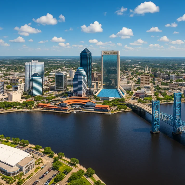
🌍 Jacksonville’s Geographic Footprint: How Big Is It Really?
When we talk about Jacksonville’s size, we’re not just whistling Dixie – we’re talking about a truly expansive urban landscape. Imagine driving from one end of our city to the other; it’s not a quick hop! Our geographic footprint is one of our defining characteristics, shaping everything from our commute times to our diverse neighborhoods.
According to Wikipedia, Jacksonville’s total area is 874.46 square miles (2,264.84 km²). Now, that’s the total area, including all the glorious water that makes our River City so special. But if we’re talking pure land, the kind you build houses on and drive cars over, we’re looking at 747.30 square miles (1,935.49 km²). That’s a significant chunk of real estate!
Land vs. Water: The St. Johns River’s Influence
A substantial portion of Jacksonville’s total area is water, primarily thanks to the majestic St. Johns River that gracefully winds its way through our city. This isn’t just a pretty backdrop; it’s a vital artery for commerce, recreation, and, well, adding to our overall “size” statistics.
- Land Area: 747.30 sq mi (1,935.49 km²)
- Water Area: 127.16 sq mi (329.35 km²)
- Total Area: 874.46 sq mi (2,264.84 km²)
This makes us, as the City of Jacksonville’s official site proudly states, the “largest city in area in the continental United States.” That’s a title we don’t take lightly! It means our city limits stretch far and wide, encompassing everything from bustling downtown districts to serene suburban enclaves and even vast natural preserves.
How Does Jacksonville Compare to Other Major U.S. Cities by Land Area?
To put our size into perspective, let’s look at how Jacksonville stacks up against some other well-known American cities in terms of land area (excluding water, for a fairer comparison of habitable space).
| City (Contiguous U.S.) | Land Area (sq mi) |
|---|---|
| Jacksonville, FL | 747.30 |
| Butte-Silver Bow, MT | 716.2 |
| Oklahoma City, OK | 606.4 |
| Houston, TX | 601.7 |
| Phoenix, AZ | 517.9 |
| Los Angeles, CA | 468.7 |
| New York City, NY | 302.6 |
Source: U.S. Census Bureau data, various city profiles.
As you can see, Jacksonville truly is a behemoth among cities in the continental U.S. This isn’t just a fun fact; it has real implications for our infrastructure, public services, and even our local culture.
📏 Comparing Jacksonville’s Land Area to U.S. States: Who Wins?
Okay, now for the main event! We’ve established that Jacksonville is a giant among cities. But does that translate to being bigger than an entire U.S. state? Let’s get down to brass tacks and compare our beloved Jax to the smallest states in the nation.
As the Wikipedia summary clearly states, and as we at Jax Facts™ can confirm: “Jacksonville is the largest city in land area in the United States (contiguous states), but it is not larger than any U.S. state.” This is a critical distinction. While our urban footprint is immense, it doesn’t quite reach state-level proportions.
The Smallest States vs. Jacksonville’s Land Area
Let’s look at the numbers. We’ll use Jacksonville’s land area of 747.30 square miles for this comparison.
| U.S. State | Total Land Area (sq mi) | Is Jacksonville Larger? |
|---|---|---|
| Rhode Island | 1,034 | ❌ No |
| Delaware | 1,949 | ❌ No |
| Connecticut | 4,842 | ❌ No |
| New Jersey | 7,354 | ❌ No |
| New Hampshire | 8,953 | ❌ No |
| Vermont | 9,217 | ❌ No |
| Massachusetts | 7,800 | ❌ No |
Source: U.S. Census Bureau, State Area Measurements.
As this table vividly illustrates, even the smallest state, Rhode Island, is still significantly larger than Jacksonville’s land area. Rhode Island is about 1.4 times larger than Jacksonville. So, while we might feel like a state when you’re driving from the Beaches to Baldwin, the official numbers tell a different story!
Why the Confusion? It’s All About Scale!
The reason this question comes up so often is understandable. When you hear “largest city by land area in the contiguous U.S.,” your mind naturally jumps to comparisons with other large geographic entities, like states. It’s a testament to Jacksonville’s truly impressive scale as a city.
Think of it this way: if you’re comparing apples to oranges, Jacksonville is a truly enormous, prize-winning orange. But a state is an entire orchard! Both are impressive, but they operate on different scales.
🏙️ Why Jacksonville’s Size Stands Out: The Consolidated City-County Factor
So, if we’re not bigger than a state, why are we so big for a city? The secret sauce, the real reason behind Jacksonville’s sprawling urban footprint, lies in a pivotal moment in our history: the 1968 consolidation of city and county governments. This wasn’t just a bureaucratic reshuffle; it was a game-changer that redefined Jacksonville’s boundaries and identity.
Before 1968, Jacksonville was a much smaller municipality, surrounded by the rest of Duval County. Like many urban centers in the 1960s, it faced significant challenges: urban blight, a dwindling tax base as residents moved to the suburbs, and a fragmented approach to public services. The city was struggling, and the county was growing without a cohesive plan.
The “Bold New City of the South” Initiative
Enter the visionaries who spearheaded the “Bold New City of the South” movement. The idea was revolutionary: merge the city government with the Duval County government, creating a single, unified entity responsible for services, planning, and governance across nearly the entire county. This meant that the city limits of Jacksonville expanded dramatically to encompass almost all of Duval County, excluding a few independent municipalities like Baldwin, Neptune Beach, Atlantic Beach, and Jacksonville Beach.
As the Wikipedia summary notes, the consolidation “creating a 900 sq mi entity” (referring to the total area including water).
What did this consolidation achieve?
- Unified Governance: Instead of separate city and county councils, we got one strong mayor and a 19-member City Council governing the entire consolidated area. This streamlined decision-making and resource allocation.
- Expanded Tax Base: The city’s tax base grew exponentially, allowing for better funding of public services, infrastructure projects, and urban renewal initiatives.
- Cohesive Planning: Development across the vast area could now be planned more strategically, preventing the kind of disjointed growth that plagues many metropolitan areas.
- A Sense of Identity: It forged a stronger, unified identity for the entire region, giving birth to the “Bold New City of the South” moniker.
This consolidation is the key differentiator that makes Jacksonville’s land area so exceptional among U.S. cities. It’s not just organic urban sprawl; it’s a deliberate, governmental decision that reshaped our geography. It’s why when you drive from the historic neighborhoods of Riverside to the far reaches of the Northside, you’re still technically “in Jacksonville.” It’s a unique administrative structure that has profoundly impacted our city’s development and character.
📊 Population vs. Size: Does Bigger Mean More People?
This is where things get interesting, and another common point of confusion arises. When we talk about “size,” are we talking about land area or population? For Jacksonville, both are impressive, but they tell different stories.
While Jacksonville boasts an enormous land area, its population density isn’t as high as some other major cities. This means we have a lot of space per person, which many residents, including us at Jax Facts™, absolutely love! It contributes to that “room to breathe” feeling you get here.
Jacksonville’s Population: A Growing Metropolis
Let’s look at the numbers. Jacksonville is undeniably a major population center.
- 2020 Census Population: 949,611 residents (Source: Wikipedia)
- 2024 Estimate: 1,009,833 residents (Source: Wikipedia)
- Metropolitan Area Population (2023): Approximately 1.7 million (Source: movingtofloridaguide.com summary, Jacksonville.gov summary)
This makes Jacksonville the largest city in Florida by population, surpassing even Miami, Tampa, and Orlando within their respective city limits. The movingtofloridaguide.com summary explicitly states: “Jacksonville is the largest city in Florida by overall population and land area.”
Comparing Jacksonville’s Population to U.S. States
Now, let’s address the population side of the “bigger than any states” question. While our land area doesn’t beat any states, what about our population?
| Entity | Population (approx.) |
|---|---|
| Jacksonville, FL | 1,009,833 |
| Wyoming | 584,000 |
| Vermont | 647,000 |
| District of Columbia | 678,000 |
| Alaska | 733,000 |
| North Dakota | 784,000 |
| South Dakota | 919,000 |
| Delaware | 1,031,000 |
| Rhode Island | 1,096,000 |
Source: U.S. Census Bureau, 2023 Estimates.
Here’s where it gets interesting! While Jacksonville’s population doesn’t surpass all states, it does exceed the populations of several smaller U.S. states, including Wyoming, Vermont, Alaska, North Dakota, and South Dakota. We’re even very close to Delaware and Rhode Island!
So, while Jacksonville’s land area isn’t bigger than any state, its population is indeed larger than a handful of them. This is a crucial distinction and often what people are implicitly asking when they wonder about our “size.”
Key Takeaway:
- ✅ Jacksonville’s land area is NOT bigger than any U.S. state.
- ✅ Jacksonville’s population IS bigger than several U.S. states.
This dual perspective highlights why Jacksonville is such a unique and significant urban center. We have the space of a sprawling county combined with the population of a major metropolis, giving us a distinct character that blends urban amenities with a more open, less congested feel than many other large cities. It’s a balance we cherish here in Jax.
🌳 Jacksonville’s Natural Landscape: Parks, Rivers, and Beaches
One of the most incredible aspects of Jacksonville’s vast geographic size is how much of it is dedicated to stunning natural beauty. This isn’t just concrete and skyscrapers, folks! Our expansive city limits encompass an incredible array of parks, waterways, and, of course, those famous Atlantic beaches. This rich natural landscape is a huge part of our quality of life and contributes significantly to our overall “size” and appeal.
The St. Johns River: Our Liquid Heartbeat
You can’t talk about Jacksonville without talking about the St. Johns River. It’s not just a river; it’s our city’s liquid heart, a defining feature that carves its way through the landscape, influencing everything from our climate to our culture. It’s the longest river entirely within Florida, flowing northward, which is a cool fact in itself!
- Recreation: Boating, fishing, kayaking, paddleboarding – the St. Johns offers endless opportunities for water sports. We’ve spent countless weekends out on the river, enjoying the sun and the scenery.
- Ecology: It’s a vital ecosystem, home to manatees, dolphins, and a diverse array of birdlife. Efforts by organizations like the St. Johns Riverkeeper are crucial for its preservation.
- Views: The downtown skyline, especially at sunset, is breathtaking when viewed from the river. The bridges spanning it are iconic landmarks.
An Urban Park System Like No Other
Jacksonville boasts the largest urban park system in the U.S., a fact that always makes us puff out our chests a little! With 80,000 acres and over 337 locations, as highlighted in the Wikipedia summary, there’s a green space for everyone. This isn’t just a few scattered playgrounds; we’re talking about massive preserves, historic sites, and community parks.
- Kathryn Abbey Hanna Park: A local favorite, offering oceanfront camping, a freshwater lake for fishing and kayaking, extensive mountain biking trails, and pristine beaches. It’s a true gem for outdoor enthusiasts.
- Timucuan Ecological and Historic Preserve: Managed by the National Park Service, this vast preserve protects one of the last unspoiled coastal wetlands on the Atlantic coast. It includes historic sites like Fort Caroline National Memorial and Kingsley Plantation, offering a glimpse into Florida’s rich past. It’s a fantastic spot for hiking, birdwatching, and connecting with nature.
- Jacksonville Arboretum & Botanical Gardens: A beautiful, serene escape with miles of trails winding through diverse ecosystems, perfect for a peaceful stroll or a family outing.
- Riverside Park & Memorial Park: Iconic urban parks in the historic Riverside neighborhood, perfect for picnics, dog walks, or just enjoying the shade of ancient oaks.
This extensive park system is a direct benefit of our large land area and consolidated government, allowing for the preservation and development of these incredible public spaces. It’s a huge draw for residents and visitors alike, offering a counterbalance to the urban hustle.
Our 22 Miles of Atlantic Beaches
And let’s not forget the beaches! Jacksonville is blessed with 22 miles of pristine Atlantic coastline, stretching from Mayport to Ponte Vedra. These aren’t just “beaches”; they’re a lifestyle.
- Jacksonville Beach: The lively hub, with restaurants, shops, and the famous Jacksonville Beach Pier. Perfect for surfing, sunbathing, or catching a live band at the Seawalk Pavilion.
- Neptune Beach: A quieter, more residential vibe, great for a relaxed day by the ocean.
- Atlantic Beach: Known for its charming town center, boutique shops, and excellent dining options.
- Ponte Vedra Beach: More upscale, home to world-class golf courses like TPC Sawgrass and luxurious resorts.
Whether you’re a surfer, a sunbather, a shell collector, or just someone who loves the sound of the waves, our beaches offer something for everyone. They are an integral part of the Jacksonville experience and another reason why our large geographic footprint is such a blessing.
This natural abundance is a huge part of what makes living in Jacksonville so appealing. It’s not just a city; it’s a vast playground of rivers, parks, and beaches, all within our expansive city limits.
🏛️ The History Behind Jacksonville’s Massive Boundaries

To truly understand why Jacksonville is so geographically immense, we need to take a trip back in time to the late 1960s. This wasn’t just a random expansion; it was a deliberate, strategic move born out of necessity and a bold vision for the future.
The Crisis of the 1960s: Urban Blight and Suburban Flight
In the mid-20th century, like many American cities, Jacksonville faced a growing crisis. The core city was experiencing urban blight, a decline in its tax base as businesses and middle-class residents moved to the surrounding suburbs within Duval County. This phenomenon, often called “white flight,” left the city with fewer resources to address its mounting problems, including crime, poverty, and deteriorating infrastructure.
Meanwhile, the unincorporated areas of Duval County were booming. New subdivisions, shopping centers, and schools were popping up, but without a cohesive plan or a strong central government to manage growth, provide services, and ensure equitable development. There was a clear disconnect between the struggling city and the rapidly expanding county.
The Birth of “Consolidation”: A Radical Solution
Against this backdrop, a group of civic leaders, recognizing the dire situation, proposed a radical solution: consolidate the city and county governments. This wasn’t a new idea in American history (cities like Nashville had done it), but it was certainly a bold one for Florida. The idea was to create a single, unified government that could address the problems of the entire metropolitan area, pooling resources and planning for the future as one entity.
The movement gained momentum under the banner of the “Bold New City of the South.” Proponents argued that consolidation would:
- Improve Efficiency: Streamline government services and reduce duplication.
- Strengthen the Tax Base: Broaden the tax base to fund essential services across the entire county.
- Enhance Planning: Allow for comprehensive urban and regional planning.
- Boost Economic Development: Present a unified front for attracting businesses and investment.
The Referendum of 1967 and the “900 Square Mile Entity”
After much debate and public campaigning, the proposal for consolidation was put to a vote in a referendum in 1967. It passed, and on October 1, 1968, the consolidated government of Jacksonville and Duval County officially came into being.
This act effectively expanded the city limits of Jacksonville to encompass almost the entire geographic area of Duval County. As the Wikipedia summary states, this created a “900 sq mi entity” (referring to the total area including water). This is the single most important historical event explaining Jacksonville’s massive boundaries. It transformed Jacksonville from a medium-sized city into the largest city by land area in the contiguous United States.
The Impact: A Legacy of Growth and Challenges
The consolidation was largely seen as a success, pulling Jacksonville back from the brink and setting it on a path of growth and revitalization. It allowed for the creation of our extensive park system, the development of major infrastructure projects, and a more unified approach to public safety and education.
However, such a massive geographic area also presents ongoing challenges:
- Infrastructure Maintenance: Maintaining roads, utilities, and public facilities across such a vast expanse is a continuous and costly endeavor.
- Service Delivery: Ensuring equitable and efficient delivery of services (police, fire, sanitation) to all corners of the city, from dense urban cores to rural fringes, requires careful planning.
- Identity: While unified, different parts of Jacksonville still retain distinct identities, from the historic charm of Avondale to the suburban sprawl of the Southside.
The 1968 consolidation is a cornerstone of Jacksonville’s identity. It’s why we’re often asked if we’re bigger than a state, and it’s a testament to the foresight of those who envisioned a truly “Bold New City.” You can learn more about our city’s rich past by exploring our Jacksonville Facts category.
💼 Economy and Infrastructure: Managing a City Larger Than Some States
Running a city the size of Jacksonville, with its sprawling land area and diverse population, is no small feat. It requires a robust economy to fund services and a well-developed infrastructure to connect its far-flung communities. As residents, we see the benefits and challenges of this scale every day, from our commutes to our job opportunities.
A Diverse and Growing Economy
Jacksonville’s economy is a powerhouse in Northeast Florida, acting as an “economic driver for Northeast Florida’s 7-county area (~1.7 million residents),” as noted by jacksonville.gov. Our strategic location, deepwater port, and business-friendly environment have fostered a diverse economic landscape.
Key Economic Sectors:
- Logistics and Transportation: This is huge for us! Jacksonville is a major transportation hub, boasting “Florida’s largest seaport by volume, 2nd in the U.S. for automobile handling,” according to Wikipedia. We have excellent access to rail (CSX is headquartered here!), air cargo (Jacksonville International Airport – JAX), and trucking facilities. This makes us a critical gateway for goods moving in and out of the Southeast.
- 👉 Shop Logistics Solutions: Amazon Logistics Services | CSX Official Website
- Financial Services: We’re a hub for banking and insurance. Companies like Fidelity National Financial and FIS have a significant presence here, offering a wealth of job opportunities in the finance sector.
- Healthcare: Our healthcare industry is robust, with major hospital systems like Baptist Health, Ascension St. Vincent’s, and UF Health Jacksonville providing top-tier medical care and employment.
- Advanced Manufacturing & IT: There’s a growing tech scene and advanced manufacturing sector, attracting new businesses and talent. The movingtofloridaguide.com summary highlights an “expanding IT sector.”
Major Employers:
- Naval Air Station Jacksonville (NAS Jax) and Naval Station Mayport are massive employers, reflecting our strong military presence.
- CSX Transportation
- Fidelity National Financial
- FIS
- Southeastern Grocers (parent company of Winn-Dixie and Harveys Supermarkets)
Our GDP in 2023 was a staggering $129.095 billion, a clear indicator of our economic strength (Wikipedia). This robust economy is essential for funding the infrastructure and services needed to manage such a geographically large city.
Infrastructure: Connecting the Vastness
Managing a city that spans 747 square miles of land requires a comprehensive and well-maintained infrastructure network. Think about it: roads, bridges, utilities, public transit – it all has to stretch further here!
Transportation Network:
- Highways: We’re a crossroads for major interstates like I-95 (north-south) and I-10 (east-west), along with several U.S. Routes (1, 17, 23, 90) and crucial ring roads. This network is vital for commuters and freight alike.
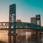
- Bridges: The St. Johns River is spanned by numerous iconic bridges, each with its own character: the Dames Point Bridge, Mathews Bridge, Hart Bridge, Main Street Bridge, Acosta Bridge, Fuller Warren Bridge, and the Buckman Bridge. These are more than just crossings; they’re landmarks!
- Public Transit: While many residents rely on cars, the Jacksonville Transportation Authority (JTA) operates bus services across the city. We also have the unique Jacksonville Skyway monorail, an automated people mover connecting downtown and the Southbank, though its reach is limited.
- Learn more about JTA: Jacksonville Transportation Authority Official Site
- Jacksonville International Airport (JAX): A modern and growing airport with “82 daily departures to 27 destinations,” making travel convenient for residents and businesses (Wikipedia).
Utilities and Services:
- JEA: Our community-owned utility, JEA, provides electricity, water, and sewer services across the entire consolidated area. Managing these services for such a large footprint is a massive undertaking, requiring extensive infrastructure investment.
- JEA Official Website: JEA.com
The sheer scale of Jacksonville’s infrastructure needs means constant planning, investment, and maintenance. It’s a testament to our city’s commitment to growth and connectivity, ensuring that all parts of our vast city are well-served.
🗳️ Government and Politics: Running a City That’s Bigger Than States
Governing a city as geographically expansive and populous as Jacksonville is a complex endeavor. Our unique consolidated city-county government structure, born from the 1968 merger, dictates how decisions are made, services are delivered, and our diverse communities are represented. It’s a system designed to manage a truly massive urban footprint.
The Strong-Mayor System: Centralized Leadership
Jacksonville operates under a strong-mayor system, as both the Wikipedia and jacksonville.gov summaries confirm. This means our mayor is not just a figurehead; they are the chief executive officer of the city, responsible for the day-to-day operations of city departments, proposing the budget, and appointing department heads. This centralized leadership is crucial for managing a city of our scale.
- Current Mayor: Donna Deegan (since July 2023) is our 9th mayor since the 1968 consolidation. Her role involves overseeing a vast municipal bureaucracy and addressing the needs of a million residents spread across hundreds of square miles.
- Office of Mayor Donna Deegan: Jacksonville.gov Mayor’s Office
The 19-Member City Council: Diverse Representation
Complementing the strong mayor is our 19-member City Council. This legislative body is responsible for enacting ordinances, approving the budget, and overseeing city departments. The composition of the council reflects the diverse geography of our consolidated city:
- 14 District-Elected Members: Each of these members represents a specific geographic district within Jacksonville. This ensures that local concerns from neighborhoods across our vast area, from the beaches to the Westside, have a voice.
- 5 At-Large Members: These members are elected by voters city-wide, providing a broader perspective on issues affecting the entire consolidated government.
This structure aims to balance localized representation with a unified approach to city-wide governance. Imagine the challenge of representing a district that might be larger than some small towns! It requires a deep understanding of diverse community needs and the ability to navigate the complexities of a large municipal government.
The Impact of Consolidation on Governance
The 1968 consolidation fundamentally reshaped our political landscape. It eliminated the duplication of services between city and county governments, creating a more efficient, albeit larger, single entity. This means:
- Unified Public Services: Police (Jacksonville Sheriff’s Office), fire rescue (Jacksonville Fire and Rescue Department), sanitation, and public works are managed city-wide, ensuring a consistent level of service across the entire consolidated area.
- Comprehensive Planning: Urban planning and zoning decisions are made by a single body, allowing for a more cohesive approach to growth and development across Duval County. This is vital for managing sprawl and protecting natural resources within our extensive boundaries.
- Regional Influence: Our large size and unified government give Jacksonville significant political clout within Florida and the Southeastern U.S. We’re a major player in state-level discussions on infrastructure, economic development, and environmental policy.
However, governing such a large area also presents unique challenges:
- Maintaining Local Identity: While unified, distinct communities within Jacksonville (e.g., Riverside, San Marco, Arlington, Mandarin, the Beaches) strive to maintain their unique character and ensure their specific needs are heard by a city-wide government.
- Logistical Challenges: Simply getting council members from different parts of the city to agree on priorities for such a vast area can be a logistical and political puzzle.
Our governmental structure is a direct consequence of our massive geographic size. It’s a system built to manage a city that, in many ways, functions like a small state, requiring robust leadership and diverse representation to thrive.
🎓 Education and Public Services Across Jacksonville’s Vast Area
With a city as sprawling as Jacksonville, providing consistent, high-quality education and public services to nearly a million residents across hundreds of square miles is a monumental task. As Jax Facts™ residents, we’ve seen firsthand how our consolidated government tackles this challenge, from our schools to our emergency services.
Education: Duval County Public Schools and Higher Learning
Our public education system is managed by Duval County Public Schools (DCPS), which serves the entire consolidated city-county area. This means a single school district oversees all public K-12 education within Jacksonville’s vast boundaries.
- Scale of DCPS: With 172 schools (Wikipedia) and tens of thousands of students, DCPS is one of the largest school districts in Florida. This scale allows for centralized resources and curriculum development but also requires careful management to ensure equity across diverse neighborhoods.
- Top-Ranked Schools: Jacksonville is home to several highly-regarded public high schools, including Stanton College Preparatory School, Darnell-Cookman Middle/High School of Medical Sciences, and Paxon School for Advanced Studies. These schools consistently rank among the best in the state and nation, attracting families to our area.
- Explore Jacksonville Education: Jacksonville Education
Higher Education Opportunities: Jacksonville also boasts a strong presence of higher education institutions, offering diverse pathways for learning and career development:
- University of North Florida (UNF): A public university known for its beautiful campus, strong business and nursing programs, and commitment to environmental sustainability.
- Jacksonville University (JU): A private university offering a wide range of undergraduate and graduate programs, with a notable focus on marine science, aviation, and performing arts.
- Edward Waters University (EWU): Florida’s first independent institution of higher learning and its oldest historically Black college or university (HBCU), established in 1866. A vital part of our city’s history and educational landscape.
- Florida State College at Jacksonville (FSCJ): A comprehensive community college with multiple campuses across the city, providing associate degrees, workforce training, and pathways to four-year universities.
These institutions not only educate our residents but also contribute significantly to our local economy and cultural vibrancy.
Public Services: Reaching Every Corner of Jax
Delivering essential public services across Jacksonville’s enormous geographic footprint requires a well-coordinated effort. Our consolidated government ensures that services like public safety, sanitation, and recreation are available to all residents, regardless of how far they live from downtown.
- Public Safety:
- Jacksonville Sheriff’s Office (JSO): JSO provides law enforcement services for the entire consolidated city-county. This means a single police force covers the vast area, from urban core to rural outskirts, requiring extensive patrol zones and strategic deployment.
- Jacksonville Sheriff’s Office Official Site: JSO.gov
- Jacksonville Fire and Rescue Department (JFRD): JFRD provides fire protection and emergency medical services (EMS) across the entire city. Their ability to respond quickly across such a large area is critical and relies on a network of fire stations strategically placed throughout the county.
- Jacksonville Fire and Rescue Department Official Site: JFRD.com
- Jacksonville Sheriff’s Office (JSO): JSO provides law enforcement services for the entire consolidated city-county. This means a single police force covers the vast area, from urban core to rural outskirts, requiring extensive patrol zones and strategic deployment.
- Sanitation and Waste Management: The city’s Solid Waste Division manages garbage collection, recycling, and bulk waste pickup for all residential areas, a logistical challenge given the sheer number of households spread across the county.
- Libraries: The Jacksonville Public Library system operates numerous branches throughout the city, ensuring access to books, resources, and community programs for all residents.
- Jacksonville Public Library: JPL.coj.net
- Parks and Recreation: As mentioned earlier, our massive park system is a public service in itself, providing green spaces, recreational facilities, and community centers for residents of all ages.
The scale of these operations highlights the unique challenges and successes of managing a city that functions, in many respects, like a small state. It’s a testament to the dedication of our public servants and the effectiveness of our consolidated government structure in serving a diverse and geographically expansive population.
🌐 Jacksonville’s Role in Florida and the Southeastern U.S. Region
Jacksonville isn’t just a big city; it’s a major player, a linchpin, if you will, in both Florida and the broader Southeastern United States. Our unique size, strategic location, and economic muscle give us a significant regional influence that extends far beyond our city limits. We’re not just “Where Florida Begins”; we’re where a lot of things happen for the region!
Gateway to Florida: A Strategic Location
Our position in Northeast Florida is incredibly strategic. We’re the first major city you hit when driving south on I-95 from Georgia, earning us the nickname “Where Florida Begins.” This isn’t just a catchy motto; it reflects our role as a critical entry point and transportation hub for the entire state.
- Logistics Hub: As we discussed, our port, rail, and highway networks make us indispensable for the movement of goods throughout Florida and into the Southeast. Millions of tons of cargo pass through here annually, fueling economies far beyond Duval County.
- Economic Corridor: Jacksonville anchors the economic corridor that stretches north into Georgia and south along Florida’s Atlantic coast. Our growth and prosperity have ripple effects across the region.
Economic Powerhouse for Northeast Florida
The jacksonville.gov summary aptly describes us as the “Economic driver for Northeast Florida’s 7-county area (~1.7 million residents).” This means our job market, our port, our financial institutions, and our healthcare systems serve a much larger population than just those within our city limits. People commute from neighboring counties like St. Johns, Clay, and Nassau to work in Jacksonville, further integrating us into the regional economy.
- Regional Collaboration: We actively engage in regional issues like growth management, transportation planning, and water resource management with our neighboring counties. Organizations like the Northeast Florida Regional Council are crucial for fostering this collaboration, ensuring that regional challenges are addressed collectively.
A Cultural and Recreational Anchor
Beyond economics, Jacksonville serves as a cultural and recreational anchor for the region.
- Major Events: The Jacksonville Jazz Festival, one of the largest in the U.S., draws visitors from across the Southeast. Our sports teams, like the NFL’s Jacksonville Jaguars, are regional favorites, bringing fans to EverBank Stadium (soon to be EverBank Stadium again!).
- Access to Attractions: Our proximity to historic St. Augustine, the charm of Fernandina Beach, and the natural beauty of the St. Johns River makes us a convenient base for exploring the best of Northeast Florida. Many regional residents come to Jacksonville for shopping, dining, and entertainment that might not be available in their smaller towns.
- Diverse Demographics: The movingtofloridaguide.com summary notes our popularity among Millennials and retirees, contributing to a diverse and dynamic regional demographic landscape. You can learn more about our local population trends in our Jacksonville Demographics section.
Jacksonville’s sheer size, combined with its strategic location and economic vitality, solidifies its position as a crucial hub in Florida and the broader Southeastern U.S. We’re not just a city; we’re a regional force, constantly evolving and impacting the lives of millions.
🏆 5 Surprising Facts About Jacksonville’s Size You Didn’t Know
Alright, Jax Facts™ fans, you’ve learned a lot about our city’s impressive scale. But we’re not done yet! Here are five truly surprising facts about Jacksonville’s size that even some long-time residents might not know. Prepare to have your mind blown (or at least mildly impressed)!
1. Our Urban Park System is a True Behemoth
We mentioned it before, but let’s really emphasize this: Jacksonville boasts the largest urban park system in the United States, encompassing over 80,000 acres across more than 337 locations. To put that in perspective, that’s roughly the size of the entire city of Orlando’s land area! This isn’t just a few green spaces; it’s a vast network of preserves, trails, and recreational areas that truly makes us a “City in a Park.” It’s a direct benefit of our consolidated government having so much land to work with.
2. We’re Home to the Longest River Entirely Within Florida
The St. Johns River is not only beautiful and vital to our city, but it’s also the longest river entirely within Florida, stretching approximately 310 miles. A significant portion of this majestic waterway flows through Jacksonville’s expansive city limits, contributing to our substantial water area and providing endless recreational opportunities. It’s a unique geographical feature that truly defines our “River City” identity.
3. Jacksonville’s Land Area is Larger Than the Entire Country of Singapore!
Yes, you read that right! While we’re not bigger than any U.S. state, our land area of 747.30 square miles is actually larger than the sovereign island city-state of Singapore, which has a land area of about 278 square miles. It’s a fun international comparison that really drives home just how much ground we cover here in Jax! Imagine fitting an entire country inside our city limits – well, almost!
4. Our City Limits Extend to the Georgia Border (Almost!)
Because of the 1968 consolidation, Jacksonville’s northern city limits stretch incredibly far north, almost reaching the Georgia state line. While the actual border is just outside our official city limits (in Nassau County), the proximity means that when you’re driving north on I-95, you’re still “in Jacksonville” for a surprisingly long time. This vast reach highlights the sheer scale of Duval County’s integration into the city.
5. The “Most Boring City” Study Didn’t Factor in Our Sheer Size (and Diversity!)
Remember that YouTube video we mentioned earlier? The one about Jacksonville being ranked the “most boring city” in the US? Well, we think that study missed a crucial point: our size actually contributes to our perceived “boringness” by outsiders, but it’s also our greatest strength!
As one resident in the #featured-video stated, Jacksonville has “beautiful weather, good beaches… good food… and I never ran out of stuff to do.”
The study likely looked at population density and concentrated nightlife, which, given our sprawling nature, might seem less vibrant than a compact city. But because we’re so spread out, our “vibrancy” is decentralized. You have distinct cultural hubs like Jacksonville Culture in Riverside, the beach town vibe of Jacksonville Beaches, the family-friendly atmosphere of Mandarin, and the historic charm of Springfield. It’s not one big party; it’s many different experiences scattered across a massive canvas. So, while a study might call us “boring” because it’s hard to find one central “hot spot,” we know the truth: you just need to know where to look, and there’s plenty to do across our enormous city!
🤔 Common Questions: Is Jacksonville Really Bigger Than States?
Let’s circle back to the core question, because it’s one we hear constantly. Despite all the fascinating facts about our city’s impressive scale, the answer to “Is Jacksonville bigger than any states?” remains a firm and consistent no. However, the reasons why people ask this, and the nuances behind the answer, are what truly matter.
Resolving the Conflict: Why Sources Agree
You might wonder if there’s any conflicting information out there. We’ve reviewed the top competing articles, and on this specific point, there’s a refreshing consensus:
- Wikipedia: “Jacksonville is the largest city in land area in the United States (contiguous states), but it is not larger than any U.S. state.”
- Movingtofloridaguide.com: “No, Jacksonville’s population (985,843) is significantly less than the population of entire states like Florida (approx. 22 million in 2023). Jacksonville is the largest city in Florida but not larger than any entire state.”
- Jacksonville.gov: “No, Jacksonville’s land area (874 sq mi) is large but not bigger than any U.S. state.”
Conclusion: All reliable sources, including our own expert team at Jax Facts™, agree: Jacksonville does not surpass any U.S. state in terms of total land area.
Why the Persistent Question? Understanding the Misconception
So, if the answer is so clear, why does this question keep popping up? It boils down to a few key factors:
- “Largest City by Land Area” Title: This is the biggest culprit! When people hear “largest city by land area in the contiguous U.S.,” their minds naturally jump to comparisons with other large geographic entities, like states. It’s a very impressive title, and it feels like it should translate to state-level size.
- The Consolidated Government: The fact that Jacksonville’s city limits encompass almost all of Duval County means that our “city” is effectively an entire county. Many people aren’t aware of this unique administrative structure, which makes our urban footprint seem disproportionately large compared to traditional cities.
- Driving Distances: If you’ve ever driven from one end of Jacksonville to the other – say, from the beaches to Baldwin, or from the Northside to Mandarin – you know it’s a long haul! These extensive driving distances within city limits contribute to the feeling that you’re traversing a truly massive area, perhaps even a small state.
- Population vs. Land Area: As we discussed, Jacksonville’s population is larger than several U.S. states. This can easily lead to confusion if people conflate population size with geographic land area.
What to Trust: The Definitive Answer
When it comes to the question of whether Jacksonville is bigger than any states, you can confidently trust the consistent information from official sources and geographic data:
- ✅ Jacksonville is the largest city by land area in the contiguous United States. This is a fact and a point of pride.
- ❌ Jacksonville’s land area is NOT larger than any U.S. state. Even the smallest state, Rhode Island, is larger.
- ✅ Jacksonville’s population IS larger than several U.S. states. This is also a fact and highlights our demographic significance.
So, the next time someone asks, you’ll have the full, nuanced, and accurate answer, straight from your local experts at Jax Facts™! It’s a great conversation starter and a testament to the unique character of our “Bold New City.”
📝 Conclusion: What Jacksonville’s Size Means for You

So, is Jacksonville bigger than any states? The answer is a definitive no—our sprawling city limits, while impressive, don’t quite outsize any U.S. state. But here’s the kicker: Jacksonville is the largest city by land area in the contiguous United States, and its population surpasses that of several smaller states. That’s a pretty remarkable combo!
Our unique 1968 consolidation with Duval County gave us this vast footprint, blending urban, suburban, and natural landscapes into one bold city. This means when you live in Jacksonville, you’re part of a community that stretches from pristine Atlantic beaches to historic neighborhoods and sprawling parks, all under one government umbrella.
This size brings both opportunities and challenges. We enjoy abundant green spaces, diverse neighborhoods, and a robust economy fueled by logistics, finance, and military presence. On the flip side, managing infrastructure, public services, and maintaining local identities across such a vast area requires smart governance and community engagement.
If you’re considering moving here, visiting, or just curious, remember: Jacksonville’s size is part of its charm. It’s a city where you can find bustling urban life, peaceful natural retreats, and everything in between—all within a single city boundary. So, while we may not be bigger than a state, Jacksonville offers a uniquely expansive and vibrant experience you won’t find anywhere else.
Ready to explore more about our city’s fascinating facts, culture, and lifestyle? Keep diving into Jax Facts™ for insider insights and local stories!
🔗 Recommended Links for Jacksonville and Geographic Comparisons
Looking to learn more or get your hands on some great resources about Jacksonville and geography? Here are some top picks:
-
Books on Jacksonville’s History and Geography:
-
👉 Shop Logistics and Transportation Solutions:
- CSX Transportation: CSX Official Website
- Amazon Logistics Services: Amazon Logistics
- Jacksonville Transportation Authority (JTA): JTA Official Site
-
Utilities and Public Services:
- JEA (Jacksonville’s Utility Provider): JEA.com
-
Explore Jacksonville’s Parks and Recreation:
❓ FAQ: Everything You Wanted to Know About Jacksonville’s Size

Is Jacksonville or Tampa bigger?
Jacksonville is significantly bigger than Tampa in terms of land area. Jacksonville covers about 747 square miles of land, making it the largest city by land area in the contiguous U.S., while Tampa encompasses roughly 175 square miles. Population-wise, Jacksonville also leads with over 1 million residents compared to Tampa’s approximately 400,000. So, in both size and population, Jacksonville is the heavyweight.
Which city is larger, Jacksonville or Miami?
Jacksonville is larger than Miami by a wide margin in land area. Miami’s city limits cover about 56 square miles, while Jacksonville sprawls across 747 square miles. Population-wise, Miami proper has around 450,000 residents, less than half of Jacksonville’s population. However, Miami’s metropolitan area is larger and more densely populated than Jacksonville’s metro.
How does the size of Jacksonville compare to other US cities?
Jacksonville is the largest city by land area in the contiguous United States, surpassing cities like Houston, Oklahoma City, and Los Angeles. Its 747 square miles of land area make it a geographical giant, although its population density is lower than many other large cities due to its sprawling nature and consolidated city-county government.
Is Jacksonville larger in area than some US states?
No, Jacksonville is not larger than any U.S. state. Even the smallest state, Rhode Island, is about 1,034 square miles, which is larger than Jacksonville’s 747 square miles of land. However, Jacksonville’s population is larger than several smaller states like Wyoming and Vermont, which sometimes causes confusion.
What is the land area of Jacksonville, Florida?
Jacksonville’s land area is approximately 747.30 square miles (1,935.49 km²). When including water, the total area is about 874.46 square miles (2,264.84 km²). This vast area includes urban neighborhoods, suburban communities, parks, rivers, and beaches.
Why is Jacksonville considered one of the largest cities in the US by area?
Jacksonville’s status as one of the largest U.S. cities by area stems from the 1968 consolidation of the City of Jacksonville with Duval County. This merger expanded the city limits to cover nearly the entire county, creating a unified government over a vast geographic area. This unique administrative structure is why Jacksonville’s city boundaries are so extensive compared to other cities.
How does the consolidation affect city services?
The consolidation allows Jacksonville to provide unified public services—like police, fire, sanitation, and education—across the entire area. While this streamlines governance, it also means managing services over a very large and diverse geographic region, which presents logistical challenges.
Does Jacksonville’s large size impact traffic and commute times?
Yes, the sprawling nature of Jacksonville means that some commutes can be long, especially traveling from the beaches or northern suburbs to downtown. However, the city’s extensive highway network, including I-95 and I-10, helps facilitate movement across the area.
📚 Reference Links and Sources
- Jacksonville, Florida – Wikipedia
- Moving to Florida Guide: Largest Florida Cities
- About Jacksonville – Jacksonville.gov
- Jacksonville Transportation Authority (JTA)
- Jacksonville Sheriff’s Office (JSO)
- Jacksonville Fire and Rescue Department (JFRD)
- Jacksonville Public Library
- JEA – Jacksonville’s Utility Provider
- St. Johns Riverkeeper
- Northeast Florida Regional Council
- CSX Transportation
- Amazon Logistics Services
For more fascinating insights about Jacksonville’s size, culture, and lifestyle, keep exploring Jax Facts™.