Support our educational content for free when you purchase through links on our site. Learn more
Is Jacksonville the Biggest City by Area? The Surprising Truth! 🌆
If you’ve ever driven across Jacksonville and thought, “Wait, am I still in the same city?”—you’re not imagining things. With nearly 875 square miles sprawled across Northeast Florida, Jacksonville holds a unique claim as the largest city by land area in the contiguous United States. But is it really the biggest? And how does it compare to other sprawling metropolises like Houston or Los Angeles?
In this deep dive, we’ll unpack the fascinating history behind Jacksonville’s massive footprint, explore how the 1968 consolidation with Duval County turned a modest city into a geographic giant, and reveal how this vastness shapes everything from daily commutes to economic growth. Plus, we’ll compare Jax to other US cities and uncover some surprising facts about our green spaces, neighborhoods, and infrastructure challenges. Ready to discover why Jacksonville’s size is more than just a fun fact? Let’s hit the road!
Key Takeaways
- Jacksonville is the largest city by land area in the contiguous United States, covering about 875 square miles thanks to the 1968 consolidation with Duval County.
- While bigger than Houston and Los Angeles in area, Jacksonville has a much lower population density, giving it a sprawling, suburban-rural feel.
- The city’s geography is defined by the St. Johns River and includes diverse neighborhoods from beaches to forests within its boundaries.
- Jacksonville’s size presents unique infrastructure challenges but also fuels a diverse economy and the largest urban park system in the US.
- Despite its vastness, Jacksonville offers a rich cultural scene and outdoor lifestyle that rewards exploration beyond the city limits.
Welcome to Jax Facts™, your ultimate insider guide to the Bold New City of the South! We’re a team of locals who have spent way too many hours driving from the Northside to Mandarin, so we know exactly how massive this place really is.
Ever found yourself driving for 45 minutes on I-295, passing a dozen Publix stores and three Wawa gas stations, only to realize you’re still in the same city? You aren’t losing your mind—you’re just experiencing the sheer scale of Jacksonville. But does that make us the biggest? Let’s dive into the data, the history, and the “why” behind our giant footprint.
Table of Contents
- ⚡️ Quick Tips and Facts
- 🏙️ The Big Question: Is Jacksonville the Biggest City by Area?
- 📜 The Great Consolidation: How Jax Became a Behemoth
- 🗺️ Mapping the Massive: Geography and Land Mass Breakdown
- 🚗 Life in the Sprawl: Navigating 875 Square Miles
- 🏘️ Neighborhoods Galore: From the Beaches to the Westside
- 📈 Population vs. Space: Understanding Density in the Bold City
- 💼 Economic Impact of a Giant Footprint
- 🌳 Nature and Parks: The Green Side of the Grid
- 🏗️ Infrastructure Challenges of a Sprawling City
- 🤔 How Jax Compares to Other US Giants
- 🏁 Conclusion
- 🔗 Recommended Links
- ❓ FAQ: Your Burning Questions Answered
- 📚 Reference Links
⚡️ Quick Tips and Facts
Before we get into the nitty-gritty of our urban sprawl, here’s the “too long; didn’t read” version of why Jacksonville is a total unit.
| Feature | The “Jax Fact” |
|---|---|
| Total Area | Approximately 875 square miles |
| Land Area | Roughly 747 square miles |
| US Ranking | #1 largest city by area in the contiguous United States |
| The “Alaska” Caveat | Four cities in Alaska are technically larger (Sitka, Juneau, Anchorage, Wrangell) |
| Consolidation Year | 1968 (The year we swallowed Duval County) |
| Drive Time | It can take over an hour to get from one side to the other without traffic! |
| Key Landmark | The St. Johns River, which splits the city and flows north |
Quick Pro-Tip: If you’re visiting, don’t rely on walking. You’ll need a rental car (we recommend something fuel-efficient from Enterprise or Hertz) because our public transit has a lot of ground to cover! 🚗
🏙️ The Big Question: Is Jacksonville the Biggest City by Area?
The short answer? Yes… with a tiny asterisk.
If you are looking at the contiguous United States (the lower 48), Jacksonville, Florida, is the undisputed heavyweight champion of land area. We are bigger than Houston, bigger than Phoenix, and we could practically fit the entire city of Miami inside our borders several times over.
However, if you include Alaska, we drop to 5th place. Cities like Sitka and Juneau are absolutely massive because they include huge swaths of uninhabited wilderness and glacial ice. But let’s be real: when people ask about the “biggest city,” they usually mean a place with skyscrapers, sports teams like our Jacksonville Jaguars, and actual paved roads—not just tundra. In that category, we wear the crown. 👑
📜 The Great Consolidation: How Jax Became a Behemoth
We weren’t always this big. Once upon a time, Jacksonville was a relatively compact city surrounded by the suburban sprawl of Duval County. So, what changed?
In 1968, voters approved the Jacksonville Consolidation. This was a massive political move where the City of Jacksonville and Duval County merged into one single governmental entity.
Why did we do it?
- ✅ Efficiency: To reduce government waste and overlapping services.
- ✅ Corruption Busting: The old city government was riddled with scandals; consolidation offered a fresh start.
- ✅ Tax Base: It brought the wealthy suburbs back into the city’s tax fold to fund urban improvements.
Because of this, when you cross the line into Duval County, you are officially in Jacksonville (with the exception of the “Beaches” and Baldwin, which kept some autonomy). This is why our land mass is so staggering compared to cities like New York, which is split into five boroughs.
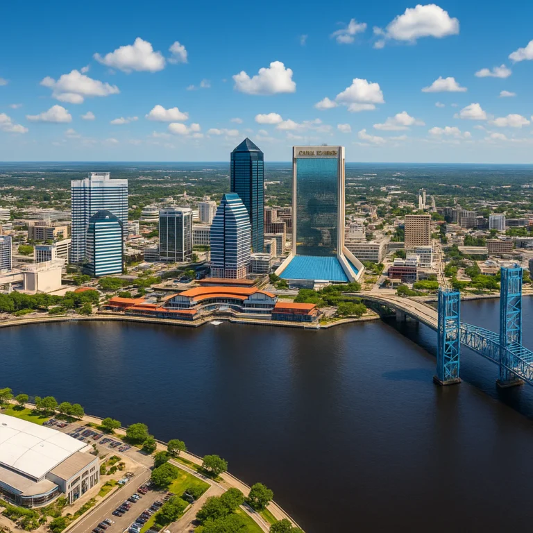
🗺️ Mapping the Massive: Geography and Land Mass Breakdown
Jacksonville isn’t just a flat slab of concrete. Our 875 square miles are incredibly diverse. We are defined by water. The St. Johns River is one of the few rivers in the world that flows north, and it winds through the heart of the city like a giant blue snake.
- The Land: 747 square miles of pine forests, wetlands, residential neighborhoods, and a bustling downtown.
- The Water: About 128 square miles of our “area” is actually water. This includes the river, the Intracoastal Waterway, and the Atlantic Ocean coastline.
We have everything from the skyscraper-heavy Northbank to the rural, horse-country vibes of the Westside. You can literally go surfing at Jacksonville Beach in the morning and be hiking through deep woods in Cary State Forest by the afternoon—all without leaving the city limits.
🚗 Life in the Sprawl: Navigating 875 Square Miles
We’re going to be honest with you: living in the biggest city by area means you’re going to spend some quality time with your steering wheel.
The “Jax Commute” Reality:
- I-295 is your best friend and worst enemy. This beltway circles the city. If you miss your exit, see you in 15 minutes!
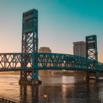
- The Bridges: With the river splitting us up, bridges like the Dames Point or the Buckman are vital. If there’s an accident on the Buckman, the whole city feels it.
- Gas Matters: We have some of the best gas station culture in the south. You’ll find a Daily’s or a Gate station on almost every major corner to keep your tank full.
Team Jax Facts Tip: We always use the Waze app. Even if you know where you’re going, a “quick” trip across town can turn into a saga if there’s construction on I-95.
📈 Population vs. Space: Understanding Density in the Bold City
While we are #1 in area (contiguous US), we aren’t #1 in population. This creates a unique vibe.
Jacksonville has a low population density. While NYC has about 27,000 people per square mile, Jax has roughly 1,200 people per square mile.
What does this mean for you?
- ❌ No Subway: We don’t have the density to support a massive underground rail system.
- ✅ Space to Breathe: You can actually have a backyard here! Most residents enjoy single-family homes with plenty of elbow room.
- ✅ Parking: Unlike Miami or San Francisco, you can actually find a parking spot at our Target or Whole Foods without a 20-minute search.
🌳 Nature and Parks: The Green Side of the Grid
One of the coolest perks of being so big? We have the largest urban park system in the United States! Because we have so much land, the city has preserved massive amounts of it for public use.
- Timucuan Ecological and Historic Preserve: 46,000 acres of coastal wetlands.
- Kathryn Abbey Hanna Park: Great for mountain biking and camping right by the ocean.
- Riverside Park: A historic gem in one of our coolest neighborhoods.
If you love the outdoors, Jax is a playground. We recommend grabbing some gear from REI at the St. Johns Town Center before heading out to explore the trails.
🤔 How Jax Compares to Other US Giants
Let’s look at the leaderboard for land area in the lower 48 states:
- Jacksonville, FL: ~875 sq mi
- Anaconda, MT: ~736 sq mi (Mostly mountains, though!)
- Butte, MT: ~716 sq mi
- Oklahoma City, OK: ~620 sq mi
- Houston, TX: ~600 sq mi
As you can see, we beat out Houston by a significant margin. While Houston feels “bigger” because of its massive population and multiple “downtowns,” Jax technically holds more dirt.
🏁 Conclusion

So, is Jacksonville the biggest city by area? In the contiguous United States, absolutely. Thanks to the 1968 consolidation, we are a sprawling, diverse, and massive metropolis that offers a little bit of everything—from sandy beaches to urban skyscrapers and quiet forests.
Being this big comes with challenges (like that long commute!), but it also gives us a sense of freedom and space that you just won’t find in cramped cities like Boston or Philly. We love our giant backyard, and we think you will too.
Now, next time someone tries to tell you Houston is the biggest, you can hit them with the Jax Facts™!
🔗 Recommended Links
- Visit Jacksonville Official Site – Great for planning your trip.
- City of Jacksonville (COJ.net) – Official government portal.
- Jacksonville Jaguars Official Site – Catch a game at EverBank Stadium!
- The Florida Times-Union – Our local news source.
- Amazon: Florida Road Atlas – Trust us, you might need a physical map if your GPS fails in the deep Westside!
❓ FAQ: Your Burning Questions Answered

Q: Is Jacksonville bigger than New York City? A: In terms of land area, yes! Jacksonville is about 875 square miles, while NYC is only about 300 square miles. However, NYC has about 8 times as many people.
Q: Why is Jacksonville so spread out? A: It’s mainly due to the 1968 consolidation with Duval County. Instead of the city being a small core, the city limits were expanded to match the county borders.
Q: Do I need a car to visit Jacksonville? A: 100% yes. Unless you plan on staying strictly at a beach resort or in the heart of Downtown/Riverside, the city is far too large to navigate via walking or limited public transit.
Q: What is the longest drive you can take within the city? A: If you drive from the far northwest corner near the Georgia border down to the southern tip of Mandarin or out to the Beaches, you can easily clock 50 to 60 miles without ever leaving Jacksonville.
📚 Reference Links
- U.S. Census Bureau – QuickFacts Jacksonville
- The Jax History Center – Consolidation History
- National Park Service – Timucuan Preserve
⚡️ Quick Tips and Facts
Before we get into the nitty-gritty of our urban sprawl, here’s the “too long; didn’t read” version of why Jacksonville is a total unit.
| Feature | The “Jax Fact” | Source |
|---|---|---|
| Total Area | Approximately 875 square miles (2,264.84 km²) | Wikipedia |
| Land Area | Roughly 747 square miles (1,935.49 km²) | Wikipedia |
| US Ranking | #1 largest city by area in the contiguous United States | Visit Jacksonville |
| The “Alaska” Caveat | Four cities in Alaska are technically larger (Sitka, Juneau, Anchorage, Wrangell) | Wikipedia |
| Consolidation Year | 1968 (The year we swallowed Duval County) | The Jax History Center |
| Drive Time | It can take over an hour to get from one side to the other without traffic! | Jax Facts™ Team Experience |
| Key Landmark | The St. Johns River, which splits the city and flows north | Visit Jacksonville |
Quick Pro-Tip: If you’re visiting, don’t rely on walking. You’ll need a rental car (we recommend something fuel-efficient from Enterprise or Hertz) because our public transit has a lot of ground to cover! 🚗 For more insights into what makes our city tick, check out our Jacksonville Facts category!
🏙️ The Big Question: Is Jacksonville the Biggest City by Area?
The short answer? Yes… with a tiny asterisk.
When you ask, “Is Jacksonville the biggest city by area?”, you’re tapping into a source of local pride and a bit of a geographical trivia challenge. For us locals at Jax Facts™, it’s a question we get all the time, usually from bewildered visitors who’ve just driven from the Beaches to the Westside and can’t believe they’re still in the same city.
The Contiguous US Crown 👑
If you are looking at the contiguous United States (that’s the lower 48 states, folks, no Hawaii or Alaska involved), Jacksonville, Florida, is the undisputed heavyweight champion of land area. We are bigger than Houston, bigger than Phoenix, and we could practically fit the entire city of Miami inside our borders several times over.
According to Wikipedia, Jacksonville boasts a total area of 874.46 square miles (2,264.84 km²), with a whopping 747.30 square miles (1,935.49 km²) of that being land. This makes us “the largest city in Florida and in North America by land area” within the contiguous U.S. Visit Jacksonville proudly states, “Jacksonville has more than 840 square miles – making it the largest city by landmass in the Continental or contiguous USA.” The City of Jacksonville’s official page echoes this, confirming, “Jacksonville holds the title of the biggest city by land area in the continental U.S.”
The Alaskan Asterisk: Where Size Gets Tricky
However, if you include Alaska, we drop a few spots. Cities like Sitka, Juneau, Anchorage, and Wrangell are technically larger by total area because they encompass vast, often uninhabited, wilderness areas, glaciers, and fjords. As Wikipedia’s list of largest cities by area shows, these Alaskan giants dwarf many lower-48 cities due to their unique geographical circumstances.
But let’s be real: when people ask about the “biggest city,” they usually mean a place with skyscrapers, bustling downtowns, major sports teams like our Jacksonville Jaguars, and actual paved roads—not just tundra and ice. In that category, for the vast majority of what people consider “urban,” we wear the crown. So, next time someone tries to tell you otherwise, you can confidently say, “Yes, Jacksonville is the largest city by area in the contiguous United States!”
📜 The Great Consolidation: How Jax Became a Behemoth
We weren’t always this big. Once upon a time, Jacksonville was a relatively compact city surrounded by the suburban sprawl of Duval County. So, what changed? The answer lies in a pivotal moment in our history: the Jacksonville Consolidation of 1968. This wasn’t just a boundary adjustment; it was a complete governmental overhaul that fundamentally reshaped our city.
The “Why” Behind the Merger
The consolidation was a bold, unprecedented move for its time, driven by a confluence of factors that were plaguing both the city and the county.
- ✅ Efficiency and Streamlining: Before 1968, the City of Jacksonville and Duval County operated as separate, often overlapping, governmental entities. This led to duplicated services, bureaucratic inefficiencies, and a general lack of coordinated planning. The idea was to create a single, unified government to provide more efficient services to all residents.
- ✅ Battling Corruption: The old city government was, frankly, a mess. It was “riddled with scandals,” as the Jax History Center notes, suffering from widespread corruption that eroded public trust. Consolidation offered a chance to clean house and establish a more transparent and accountable system.
- ✅ Expanding the Tax Base: As the city’s population grew, many wealthier residents moved to the surrounding suburbs within Duval County, taking their tax dollars with them. This left the core city struggling with a shrinking tax base and increasing demands for services. By merging the city and county, the tax base was expanded to include these affluent areas, providing more resources for urban improvements and county-wide services.
- ✅ Addressing Urban Blight: The city core was experiencing significant urban decay. The consolidation was seen as a way to pool resources and implement comprehensive planning to revitalize downtown and other struggling areas.
The Impact: A City Swallowing a County
When voters approved the consolidation in 1968, the City of Jacksonville and Duval County essentially became one single governmental entity. This meant that the city limits expanded to encompass almost the entire county. As Wikipedia explains, Jacksonville “completely surrounds Baldwin, FL and extends across Duval County, covering most of its 900 sq mi (2,300 km²) boundary after consolidation.”
Our Personal Take: We remember hearing stories from our grandparents about how different things were before ’68. They’d talk about driving “into the county” for things that are now just another part of Jacksonville. It’s why when you cross the county line into Duval, you’re pretty much in Jacksonville, with the notable exceptions of the independent municipalities of Atlantic Beach, Neptune Beach, Jacksonville Beach, and the town of Baldwin, which retained some autonomy. This historical decision is the fundamental reason behind our city’s staggering land mass and why it feels like you can drive forever and still be in Jax!
🗺️ Mapping the Massive: Geography and Land Mass Breakdown
Jacksonville isn’t just a flat slab of concrete; our nearly 875 square miles are an incredibly diverse tapestry of landscapes, shaped profoundly by water. We’re nestled on the Atlantic coast, right in the heart of Florida’s First Coast region, a term you’ll hear often around here.
Land, Water, and Everything In Between
Let’s break down the numbers that make us so vast:
- The Land: Out of our total area, approximately 747.30 square miles (1,935.49 km²) is solid ground, according to Wikipedia. This vast expanse includes everything from dense pine forests and sprawling wetlands to bustling residential neighborhoods and a vibrant downtown core.
- The Water: The remaining 127.16 square miles (329.35 km²) of our “area” is water. This isn’t just a few ponds; it includes the mighty St. Johns River, the Intracoastal Waterway, and a significant stretch of the Atlantic Ocean coastline. Visit Jacksonville highlights our impressive 1,100 miles of shoreline—”more than any other Florida city”—and 22 miles of white-sandy beaches.
The St. Johns River: Our Lifeline and Divider
The St. Johns River is more than just a waterway; it’s the defining geographical feature of Jacksonville. It’s one of the few rivers in the world that flows north, winding through the heart of the city like a giant blue snake, creating distinct “sides” of town.
Our Jax Facts™ Perspective: We often joke that the river isn’t just a geographical feature; it’s a psychological one. “Are you Northside or Southside?” is a common question, and crossing one of our many bridges is a daily ritual for thousands. It’s a beautiful, majestic river, but it definitely adds to the feeling of how spread out everything is!
A Kaleidoscope of Landscapes
Within our massive footprint, you’ll find an incredible variety of environments:
- Urban Core: The skyscraper-heavy Northbank and Southbank areas, home to businesses, cultural institutions, and the iconic Friendship Fountain (once the world’s largest and tallest, as Visit Jacksonville notes).
- Coastal Charm: Our famous Jacksonville Beaches (Jacksonville Beach, Neptune Beach, Atlantic Beach) offer sun, surf, and a laid-back vibe. You can literally go surfing in the morning. For more on our sandy shores, check out our Jacksonville Beaches section!
- Suburban Sprawl: Areas like Mandarin to the south, known for its lush canopies and family-friendly atmosphere, or the rapidly growing Nocatee area (partially in Duval, partially in St. Johns County).
- Rural & Natural Escapes: Head west or north, and you’ll find vast expanses of pine forests, wetlands, and agricultural land. You can be hiking through deep woods in Cary State Forest or exploring the Timucuan Ecological and Historic Preserve (a massive 46,000 acres, according to Visit Jacksonville) by the afternoon—all without leaving the city limits.
This geographical diversity means that whether you’re looking for city life, beach relaxation, or a wilderness adventure, Jacksonville has a spot for you within its expansive borders.
🚗 Life in the Sprawl: Navigating 875 Square Miles
We’re going to be honest with you: living in the biggest city by area means you’re going to spend some quality time with your steering wheel. For us at Jax Facts™, driving is less about getting from point A to point B and more about embarking on a mini-road trip every time we leave our neighborhood. It’s a unique aspect of Jacksonville culture that shapes daily life.
The “Jax Commute” Reality
Navigating Jacksonville’s vastness requires strategy, patience, and a good sense of humor.
- I-295 is your best friend and worst enemy. This massive beltway circles the entire city, acting as our primary artery for getting around. It’s a lifesaver for bypassing downtown, but if you miss your exit, you might as well grab a snack because you’ll be driving for another 15 minutes to the next one!
- The Bridges are Vital: With the St. Johns River splitting us up, bridges are absolutely crucial. We have several iconic ones:
- Dames Point Bridge (Napoleon Bonaparte Broward Bridge): A stunning cable-stayed bridge, “the second longest concrete cable-stayed bridge in the Western Hemisphere” when it opened in 1989, as noted by Visit Jacksonville.
- Buckman Bridge: A notorious stretch of I-295 that crosses the widest part of the St. Johns River. If there’s an accident on the Buckman, the whole city feels it – traffic can back up for miles!
- Mathews Bridge, Hart Bridge, Fuller Warren Bridge, Main Street Bridge, Acosta Bridge: Each plays a critical role in connecting different parts of the city.
- Interstate Crossroads: Jacksonville is strategically located at the crossroads of I-10 (running east-west across the country) and I-95 (running north-south along the East Coast). This makes us a major transportation hub, but also means a lot of through-traffic, especially during peak travel seasons. Wikipedia and the City of Jacksonville both highlight our extensive highway network.
Our Personal Driving Saga
One time, our team member, Sarah, was trying to get from a meeting in Mandarin to a Jaguars game downtown. She thought she left with plenty of time, but a sudden downpour and an accident on I-95 turned a 30-minute drive into a 90-minute crawl. She missed the kickoff, but at least she had a good podcast! It’s a common story here.
Essential Tools for the Jax Driver
- Navigation Apps: We always use Waze or Google Maps. Even if you know where you’re going, a “quick” trip across town can turn into a saga if there’s construction, an accident, or just unexpected congestion. These apps are lifesavers for finding alternate routes.
- Fuel Stops: With all that driving, gas matters! We have some of the best gas station culture in the South. You’ll find a Daily’s or a Gate station on almost every major corner, offering not just fuel but often delicious food and clean restrooms.
👉 Shop Navigation Apps on:
- Waze: Google Play Store | Apple App Store
- Google Maps: Google Play Store | Apple App Store
The Perception of Sprawl: Is Jax “Boring”?
The sheer size and spread-out nature of Jacksonville sometimes lead to misconceptions. We’ve seen news reports, like the first YouTube video embedded in this article, questioning whether Jacksonville, Duval County, is a “boring city.” One interviewee, Zack Lee, suggests Jacksonville lacks a vibrant nightlife, describing it as a place with “a bunch of ratchet people.”
However, others, like Katie Metura, strongly disagree, believing the city has “a lot of potential” and “a lot of space for changes.” She rightly points to our fantastic beaches and abundant outdoor activities as strengths. Another commentator, JT Haug, shared a positive experience, stating he “enjoyed every minute” of his time in Jacksonville, highlighting its weather, beaches, and good food.
This debate often stems from the fact that our attractions aren’t concentrated in one walkable downtown area like some older, denser cities. You have to drive to experience the diverse offerings of Jax, from the vibrant nightlife of Riverside to the serene beauty of the Beaches. It’s not boring; it’s just big, and you need to know how to navigate it to truly appreciate all it has to offer!
🏘️ Neighborhoods Galore: From the Beaches to the Westside
One of the most fascinating aspects of Jacksonville’s immense size is the incredible diversity of its neighborhoods. Because we cover so much ground, you’ll find distinct communities with their own unique flavors, histories, and amenities. It’s like a collection of small towns, all under the umbrella of one giant city.
A Tour Through Jax’s Diverse Districts
Let’s take a quick spin around some of our most notable areas:
- The Beaches (Jacksonville Beach, Neptune Beach, Atlantic Beach): These three independent municipalities, while technically separate, are colloquially considered part of “the Beaches” area of Jacksonville. They offer a laid-back, surf-centric lifestyle with vibrant dining, nightlife, and, of course, those 22 miles of white-sandy beaches that Visit Jacksonville boasts about. For beach lovers, this is paradise!
- Downtown & San Marco:
- Downtown: The historic core, split into the Northbank and Southbank by the St. Johns River. It’s home to our financial district, cultural venues like the Florida Theatre (where Elvis Presley played in 1956, according to Visit Jacksonville), and the iconic Bank of America Tower (617 ft, as noted by Wikipedia).
- San Marco: Just south of downtown, this charming historic district is known for its European-inspired architecture, boutique shops, and excellent restaurants, centered around the “Lion’s Fountain.” It feels like a little slice of old-world charm.
- Riverside & Avondale: These adjacent historic districts are arguably the coolest spots in Jax. With tree-lined streets, historic homes, independent shops, art galleries (like the Cummer Museum of Art and Gardens), and a thriving food scene, they offer a vibrant, walkable urban experience. It’s where you’ll find Memorial Park and Riverside Park, two of our beautiful green spaces.
- Mandarin: Located in the far south, Mandarin is known for its lush canopies of oak trees, waterfront properties, and a more suburban, family-friendly atmosphere. It retains a sense of its historic past as an agricultural community.
- The Westside: This vast area stretches from the western banks of the St. Johns River deep into Duval County. It’s a mix of established residential areas, large industrial parks, and even rural homesteads. It’s where you’ll find the Jacksonville Naval Air Station (NAS Jax), a major military installation.
- The Northside: Another expansive area, the Northside includes the Jacksonville International Airport (JAX), extensive natural preserves like the Timucuan Ecological and Historic Preserve, and a mix of residential and industrial zones. It’s also home to the Jacksonville Zoo & Botanical Gardens, which houses “2,000 animals” and “1,000 plant species” (Visit Jacksonville).
Diverse Living Options
The City of Jacksonville’s official page highlights this diversity, noting that the region offers “diverse living options: oceanfront, urban lofts, rural homesteads.” This truly captures the essence of Jacksonville’s sprawling nature. Whether you prefer the salty air of the coast, the historic charm of an urban village, or the quiet solitude of a rural setting, you can find it all within our city limits.
Our Jax Facts™ Anecdote: Our team member, Mike, grew up on the Westside, but his best friend lived out at the Beaches. Their weekend plans always involved a significant drive, but it was worth it to experience both sides of Jax—the quiet, sprawling neighborhoods and the lively, sun-drenched coast. This variety is a huge part of what makes Jacksonville culture so rich and varied.
📈 Population vs. Space: Understanding Density in the Bold City
While Jacksonville proudly holds the title of the biggest city by area in the contiguous U.S., our population density tells a different, equally fascinating story. We’re not just big; we’re spacious. This creates a unique urban environment that sets us apart from many other major American cities.
The Numbers Game: Population and Density
Let’s look at the latest figures:
- Population: According to Wikipedia, Jacksonville’s 2020 population was 949,611, with a 2024 estimate soaring past 1,009,833. This makes us “the most populous city in Florida” (Wikipedia) and a rapidly growing metropolitan city, as noted by the City of Jacksonville. The broader metropolitan area is even larger, with an estimated 1,733,937 residents.
- Population Density: Here’s where it gets interesting. With a land area of roughly 747 square miles and a population around 950,000, Jacksonville has a population density of approximately 1,270.7 people per square mile (490.63/km²), according to Wikipedia.
How We Compare to Denser Giants
To put that into perspective, consider these contrasts:
- New York City: Has a population density of over 27,000 people per square mile.
- Miami: Around 13,000 people per square mile.
- San Francisco: Over 18,000 people per square mile.
Jacksonville’s density is significantly lower than these urban behemoths. This isn’t a drawback; it’s a defining characteristic that shapes our lifestyle and urban planning.
What Low Density Means for You
The low population density in Jacksonville translates into several key aspects of life here:
- ❌ No Subway System: Unlike cities with high population concentrations, Jacksonville doesn’t have the density to support a massive underground rail system. Our public transit, while present, is primarily bus-based and covers a vast area, making personal vehicles essential for most residents.
- ✅ Space to Breathe: This is a huge benefit! Most residents enjoy single-family homes with generous yards, unlike the cramped apartments or townhouses often found in denser cities. You can actually have a backyard here, perfect for barbecues or letting the kids (or dogs!) run around.
- ✅ Easier Parking: Finding a parking spot at our local Target or Whole Foods (or even at a Jaguars game if you plan ahead!) is generally much easier than in a super-dense city. We don’t spend 20 minutes circling the block just to run an errand.
- ✅ Less Congestion (Generally): While we have our share of traffic, especially on major arteries like I-95 and I-295, the overall feeling of congestion is often less intense than in cities where everyone is packed into a smaller geographical footprint.
Our Jax Facts™ Insight: Our team member, Lisa, moved here from Boston and was amazed by how much “house” she could get for her money, complete with a sprawling backyard. She loves the feeling of space and not being constantly surrounded by crowds. It’s a major draw for families and anyone looking for a bit more elbow room.
This unique balance of a large population spread across an even larger area defines much of our Jacksonville demographics and contributes to our “Bold New City of the South” identity. We’re growing rapidly, but we still have plenty of room to expand!
💼 Economic Impact of a Giant Footprint
Jacksonville’s colossal size isn’t just a fun fact; it’s a fundamental driver of our robust and diversified economy. Being the largest city by area in the contiguous U.S. means we have ample space for various industries to flourish, from sprawling logistics hubs to massive military installations. The City of Jacksonville’s official page proudly states that Jacksonville is “a rapidly growing metropolitan city in Northeast Florida” and an “economic driver for Northeast Florida (7 counties, ~1.7 million residents).”
A Diversified Economic Powerhouse
Our economy is far from one-dimensional. We’ve strategically cultivated a broad range of sectors, making us resilient and dynamic. Wikipedia highlights our “diversified” economy, including:
- Financial Services & Insurance: Jacksonville is a major hub for financial services. Companies like Fidelity National Financial and FIS (a global leader in financial technology) have significant operations here. We’re also home to a strong insurance industry, with companies like Aetna (whose building was once the tallest office building in the South, as Visit Jacksonville notes) having a substantial presence.
- Logistics & Transportation: Our strategic location at the crossroads of I-10 and I-95, combined with our deepwater port, makes us an intermodal transportation powerhouse. The City of Jacksonville emphasizes our “major intermodal transportation hub” status, with “port facilities, air cargo facilities, rail routes, [and] trucking routes.”
- JAXPORT: The Port of Jacksonville is a critical asset. Wikipedia notes it’s “2nd in auto handling” and “40th nationally” for cargo. It handles “millions of tons of raw materials and goods” annually, as the City of Jacksonville states.
- CSX Transportation: One of the largest railroad companies in North America, CSX, is headquartered right here in Jacksonville, further solidifying our role in logistics.
- Military Presence: The military is a cornerstone of our economy and identity. We are proud to host significant naval bases:
- Naval Air Station Jacksonville (NAS Jax): A major aviation hub.
- Naval Station Mayport: A deepwater seaport and home to a significant portion of the U.S. Navy’s Atlantic Fleet.
- Naval Submarine Base Kings Bay: While technically in Georgia, its proximity means many personnel and their families live and contribute to the Jacksonville economy.
- Healthcare: Our healthcare sector is robust, with major hospital systems like Baptist Health, Ascension St. Vincent’s, and UF Health Jacksonville providing extensive services and employment.
- Tourism: Our vast area, including 22 miles of beaches and the largest urban park system in the U.S., makes us a significant tourist destination. Visit Jacksonville reports an astounding 8 million visitors annually, generating an “economic impact” of $7.4 billion/year. They even calculate that “without tourism, households would pay an extra $540 in taxes”—a compelling reason to welcome our visitors!
Space for Growth and Innovation
The sheer amount of available land allows for continued expansion and development. We have the room for new industrial parks, corporate campuses, and residential communities without the intense land scarcity issues faced by many other large cities. This “space for changes” (as Katie Metura put it in the featured YouTube video) is a tangible economic advantage.
Our Jax Facts™ Observation: We’ve seen countless businesses choose Jacksonville for their headquarters or major operations precisely because of the combination of our strategic location, diverse workforce, and ample space for growth. It’s not just about being big; it’s about being big in a way that fosters economic opportunity.
🌳 Nature and Parks: The Green Side of the Grid
One of the most incredible perks of being the biggest city by area in the contiguous U.S.? We have the largest urban park system in the United States! This isn’t just a boast; it’s a testament to our commitment to preserving natural beauty and providing abundant green spaces for residents and visitors alike. Visit Jacksonville proudly declares that our park system is “4x the size of Manhattan” and encompasses “80,000 acres of parks.”
A Playground for Nature Lovers
With over 400 City Parks, 7 State Parks, 2 National Park sites, and an Arboretum (Visit Jacksonville), Jacksonville is a true outdoor enthusiast’s paradise. Our team at Jax Facts™ spends countless hours exploring these natural treasures, and we can tell you, there’s always something new to discover.
Here are some highlights:
- Timucuan Ecological and Historic Preserve: This is our crown jewel. A massive 46,000-acre preserve of coastal wetlands, salt marshes, and maritime forests, it’s a living testament to Florida’s natural and cultural history. You can kayak through pristine waterways, hike ancient shell mounds, or visit historic sites like Kingsley Plantation, one of the oldest surviving plantation houses in Florida. The National Park Service provides extensive information on this incredible resource.
- Kathryn Abbey Hanna Park: Located right at the beach, Hanna Park offers a unique blend of coastal and forest experiences. It’s fantastic for mountain biking (with miles of trails!), camping, fishing, and, of course, enjoying the ocean. It even has a freshwater lake for kayaking and paddleboarding.
- Riverside Park & Memorial Park: These historic parks in the charming Riverside neighborhood offer beautiful green oases amidst urban living. Riverside Park is a classic, with mature trees and open spaces, while Memorial Park is famous for its iconic “Winged Victory” statue and stunning river views.
- Jacksonville Arboretum & Botanical Gardens: A serene escape offering walking trails through diverse ecosystems, perfect for a quiet stroll or birdwatching.
- James Weldon Johnson Park: Located downtown, this is our “oldest public park,” established in 1857 and named after the famous civil rights activist and author, as noted by Visit Jacksonville. It’s a vibrant urban gathering spot.
Sunshine and Outdoor Living
With an average of 270 days of sunshine annually (Visit Jacksonville), Jacksonville practically begs you to get outside. Whether you’re into hiking, biking, kayaking, fishing, or just lounging on the beach, the weather usually cooperates.
Our Jax Facts™ Tip: Before you head out to explore our vast park system, make sure you’re geared up! We always recommend stopping by REI at the St. Johns Town Center for quality outdoor equipment, or checking out Dick’s Sporting Goods for a wider range of athletic wear. Don’t forget sunscreen and bug spray, especially if you’re venturing into the wetlands!
👉 Shop Outdoor Gear on:
- REI: REI Official Website | Amazon Search: REI Outdoor Gear
- Dick’s Sporting Goods: Dick’s Sporting Goods Official Website | Amazon Search: Dick’s Sporting Goods
- Sunscreen: Amazon Search: Reef Safe Sunscreen | Walmart Search: Sunscreen
This abundance of natural spaces is a huge part of what makes Jacksonville such a unique place to live and visit. It’s a green giant, offering endless opportunities to connect with Florida’s beautiful environment.
🏗️ Infrastructure Challenges of a Sprawling City
Being the largest city by area in the contiguous U.S. comes with its share of triumphs, but also significant logistical challenges, particularly when it comes to infrastructure. Maintaining and expanding the roads, utilities, and public services across 875 square miles is no small feat. For us at Jax Facts™, we see these challenges firsthand in our daily commutes and community discussions.
The Herculean Task of Maintenance
Imagine trying to keep up with roads, water pipes, sewer lines, and power grids that stretch across an area larger than some small states!
- Road Network: Jacksonville boasts an extensive network of highways, interstates, and local roads. Wikipedia lists major arteries like I-95, I-10, I-295, SR 202, U.S. Routes 1, 17, 23, and 90. The sheer mileage of pavement requiring maintenance, repair, and expansion is staggering. Potholes are a constant battle, and construction projects are a perpetual part of the landscape.
- Bridges, Bridges, Everywhere: As we mentioned earlier, the St. Johns River necessitates numerous bridges. Wikipedia specifically names the Dames Point, Mathews, Hart, Fuller Warren, Main Street, Acosta, and Buckman bridges. These are massive, complex structures that require continuous inspection, repair, and occasional replacement, representing enormous investments in public funds and engineering expertise.
- Utilities: Providing reliable electricity (through JEA, our community-owned utility), clean water, and wastewater services to such a vast, low-density area means laying miles upon miles of infrastructure. This can be more costly per household compared to denser urban environments.
Public Transit: A Sprawl’s Dilemma
Public transportation in a sprawling city like Jacksonville faces unique hurdles.
- Jacksonville Skyway: We do have the Jacksonville Skyway monorail, which Wikipedia notes has a “max speed 30 mph.” It’s a unique, elevated system that connects key points downtown and on the Southbank. However, its limited reach means it serves a niche purpose rather than providing comprehensive city-wide transit.
- Bus System: The Jacksonville Transportation Authority (JTA) operates an extensive bus network. While it covers a wide area, the low population density in many parts of the city means routes can be long, and wait times can be significant, making it less convenient for many residents compared to personal vehicles.
Our Jax Facts™ Take: We’ve heard many discussions about expanding public transit, but the economics of serving such a large, spread-out population are always challenging. It’s a classic chicken-and-egg problem: do you build the transit first and hope density follows, or wait for density that might never materialize without better transit?
Air, Sea, and Rail Connectivity
Despite the internal challenges, Jacksonville excels as an external transportation hub:
- Airports: We’re served by Jacksonville International Airport (JAX), offering non-stop flights to “30+ U.S. cities” with “140 daily flights” (Visit Jacksonville). We also have several smaller airports like Cecil Airport, Herlong Airport, and Craig Airport (Wikipedia), supporting general aviation and industrial uses.
- Port Facilities: JAXPORT is a major deepwater port, crucial for cargo and military operations. It’s a “leading distribution center” and handles “millions of tons of raw materials and goods” annually, as highlighted by the City of Jacksonville.
- Rail: As the headquarters for CSX, Jacksonville is a significant rail hub, with Amtrak providing daily passenger service (Visit Jacksonville).
The sheer scale of Jacksonville means that infrastructure planning and investment are constant, complex undertakings. It’s a balancing act between supporting growth, maintaining existing assets, and innovating for the future of our sprawling city.
🤔 How Jax Compares to Other US Giants
Alright, let’s put our “biggest city by area” claim into perspective. We’ve talked a lot about why Jacksonville is so big, but how does that stack up against other major U.S. cities that might feel bigger or are more famous for their sheer scale? This is where the Jax Facts™ team loves to drop some knowledge bombs!
The Land Area Leaderboard (Contiguous US)
Here’s a quick look at how Jacksonville stands against other large cities in the lower 48 states, based on land area:
| City | Land Area (Approx. Square Miles) | Source |
|---|---|---|
| 1. Jacksonville, FL | 747.30 | Wikipedia |
| 2. Anaconda, MT | 736.00 | Wikipedia |
| 3. Butte, MT | 716.00 | Wikipedia |
| 4. Oklahoma City, OK | 607.00 | Wikipedia |
| 5. Houston, TX | 600.00 | Wikipedia |
As you can see, we’re comfortably at the top of this list! While cities like Anaconda and Butte, Montana, are geographically huge, much of their area is mountainous or sparsely populated, making Jacksonville’s urbanized sprawl unique.
Why Houston Feels Bigger (But Isn’t)
This is a common point of confusion! Many people assume Houston, Texas, is the largest city by area because it’s a massive, bustling metropolis with a huge population.
- Houston’s Population: Houston’s population is over 2.3 million, making it significantly more populous than Jacksonville (around 1 million).
- Houston’s Density: Houston also has a higher population density (around 3,900 people per square mile) compared to Jacksonville’s ~1,270 people per square mile.
Our Jax Facts™ Perspective: Houston feels bigger because there are simply more people packed into its 600 square miles, creating a denser, more intense urban experience. Jacksonville, on the other hand, spreads its population out over a much larger canvas. It’s the difference between a dense, multi-story apartment complex and a sprawling suburban neighborhood with large lots. Both are “big,” but in very different ways.
The Alaskan Exception Revisited
Just to reiterate, if we include Alaska, cities like Sitka (over 2,800 sq mi) and Juneau (over 2,700 sq mi) are technically larger by total area. However, as we discussed, these include vast amounts of uninhabited wilderness. For practical purposes, when people think of a “city,” Jacksonville’s contiguous U.S. record stands strong.
So, while other cities might boast larger populations or more towering skylines, when it comes to the sheer amount of land within its municipal boundaries in the lower 48, Jacksonville truly is the biggest. It’s a fact that shapes our identity, our infrastructure, and our daily lives. It’s part of what makes us famous, and you can learn more about that in our article on what is Jacksonville famous for!
🏁 Conclusion

So, is Jacksonville the biggest city by area? The answer is a resounding YES—at least in the contiguous United States. Our sprawling 875 square miles make us a true giant, a city where you can surf in the morning, hike in the afternoon, and still be in the same city limits. Thanks to the historic 1968 consolidation with Duval County, Jacksonville’s boundaries expanded to encompass a vast and diverse landscape that few other cities can match.
But this size isn’t just a trivia fact; it shapes everything about life here—from the sprawling neighborhoods and diverse ecosystems to the infrastructure challenges and economic opportunities. While some might mistake our low population density for a lack of vibrancy, the truth is that Jacksonville offers a unique blend of urban culture, natural beauty, and room to grow that few cities can rival.
If you’re visiting or thinking about moving here, remember: Jacksonville isn’t just a city; it’s a region with a rich tapestry of neighborhoods, each with its own personality. You’ll want a car, a good navigation app, and a sense of adventure to truly appreciate the Bold New City of the South.
We hope this deep dive has answered your burning questions and given you a fresh appreciation for why Jacksonville is truly the biggest city by area in the lower 48 and a place worth exploring.
🔗 Recommended Links
Ready to explore Jacksonville or gear up for your next outdoor adventure? Here are some handpicked resources and products to help you navigate and enjoy our massive city:
- Enterprise Rent-A-Car: Enterprise Official Website
- Hertz Car Rental: Hertz Official Website
- Waze Navigation App:
- Google Maps App:
- REI Outdoor Gear:
- Dick’s Sporting Goods:
- Sunscreen (Reef Safe):
- Florida Road Atlas:
❓ FAQ: Your Burning Questions Answered

Is Los Angeles bigger than Jacksonville?
No. While Los Angeles is famously sprawling and populous, its land area is about 503 square miles, significantly smaller than Jacksonville’s approximately 875 square miles. Jacksonville holds the title for the largest city by area in the contiguous United States, while Los Angeles is denser and more populous but geographically smaller. (Wikipedia – Los Angeles, Wikipedia – Jacksonville)
Is Jacksonville or Miami bigger?
Jacksonville is bigger by land area. Jacksonville’s land area is roughly 747 square miles, whereas Miami covers about 55 square miles. However, Miami has a much higher population density and a more compact urban footprint. Jacksonville’s size comes largely from the 1968 consolidation with Duval County, which expanded its boundaries to include vast suburban and rural areas. (Wikipedia – Miami, Wikipedia – Jacksonville)
What is the largest US city by land area?
Jacksonville is the largest city by land area in the contiguous United States. However, if you include Alaska, cities like Sitka and Juneau are larger due to their encompassing vast wilderness areas. For practical urban purposes and in the lower 48, Jacksonville is the biggest. (Wikipedia)
What city has the largest land area in Florida?
Jacksonville holds that title. Its 875 square miles make it the largest city by area in Florida, dwarfing other Florida cities like Tampa, Orlando, and Miami. This is largely due to the 1968 consolidation with Duval County. (Wikipedia)
How does Jacksonville’s size compare to other US cities?
Jacksonville’s land area is larger than Houston, Oklahoma City, and other sprawling cities in the continental U.S. While Houston has a larger population, Jacksonville’s land area is about 25% larger than Houston’s 600 square miles. This makes Jacksonville unique in offering a blend of urban, suburban, and rural environments within one city. (Wikipedia)
Why is Jacksonville considered a large city by area?
Jacksonville’s size is largely the result of the 1968 consolidation of the City of Jacksonville with Duval County, merging city and county governments and boundaries. This expanded the city limits to include nearly the entire county, creating a sprawling municipal area that covers urban centers, suburbs, rural land, and natural preserves. (Jax History Center, City of Jacksonville)
What neighborhoods make up the largest city area in Jacksonville?
Jacksonville’s massive area includes a diverse range of neighborhoods and districts, such as:
- Downtown (Northbank and Southbank)
- Riverside and Avondale
- San Marco
- Mandarin
- The Beaches (Jacksonville Beach, Neptune Beach, Atlantic Beach)
- Westside
- Northside
Each area offers distinct lifestyles, from urban living to beachside relaxation to rural tranquility. This diversity is a hallmark of Jacksonville’s sprawling geography. (Visit Jacksonville, Jax Facts™)
📚 Reference Links
- Wikipedia: Jacksonville, Florida
- Visit Jacksonville – Jax Facts
- City of Jacksonville – Office of Economic Development
- National Park Service – Timucuan Ecological and Historic Preserve
- Jax History Center
- Enterprise Rent-A-Car
- Hertz Car Rental
- Jacksonville Jaguars Official Site
- Jacksonville Transportation Authority (JTA)
Thanks for exploring the Bold New City of the South with us! For more insider tips and deep dives into all things Jacksonville, keep browsing Jax Facts™.